Fontegreca elevation
Fontegreca (Campania, Provincia di Caserta), Italy elevation is 321 meters and Fontegreca elevation in feet is 1053 ft above sea level [src 1]. Fontegreca is a seat of a third-order administrative division (feature code) with elevation that is 1 meters (3 ft) smaller than average city elevation in Italy.
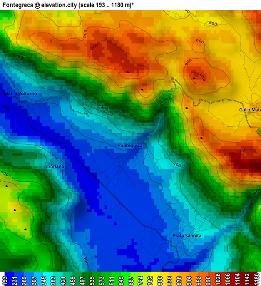
Below is the Elevation map of Fontegreca, which displays elevation range with different colors. Scale of the first map is from 193 to 1180 m (633 to 3871 ft) with average elevation of 572.9 meters (=1880 ft) [note 1]
These maps also provides idea of topography and contour of this city, they are displayed at different zoom levels. More info about maps, scale and edge coordinates you can find below images.
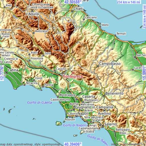
| \ | Map #1 | Topo.Map |
| Scale [m] | 193..1180 m | × |
| Scale [ft] | 633..3871 ft | × |
| Average | 572.9 m = 1880 ft | × |
| Width | 7.32 km = 4.5 mi | 234.4 km = 145.6 mi |
| Height | 7.32 km = 4.5 mi | 234.4 km = 145.6 mi |
| ↑Max Latitude | 41.489457° | 42.50188° |
| Latitude at center | 41.45653° | 41.45653° |
| ↓Min Latitude | 41.423586° | 40.39406° |
| ← Min Longitude | 14.139905° | 12.7776° |
| Longitude center | 14.18385° | 14.18385° |
| →Max Longitude | 14.227795° | 15.5901° |
Nearby cities:
Cities around Fontegreca sort by population:
• Capriati A Volturno elevation 283 m
3.4 km,  292°
292°
• Taverna Ravindola 240 m
8.8 km,  326°
326°
• Monteroduni 469 m
7.4 km,  355°
355°
• Valle Agricola 696 m
7 km,  120°
120°
• Prata Sannita Centro 324 m
3.1 km,  149°
149°
• Ailano 229 m
7.6 km,  166°
166°
• Gallo Matese 854 m
3.5 km,  75°
75°
• Pratella 169 m
5.7 km,  183°
183°
• Letino 1010 m
6 km,  93°
93°
• Longano 671 m
9 km,  35°
35°
• Gallo 840 m
3.6 km,  74°
74°
• Ciorlano 319 m
2.2 km,  251°
251°
Multilingual:
 En español:
Fontegreca elevación 321 m.
 En France:
Fontegreca élévation 321 m.
 Auf Deutsch:
Fontegreca höhe über dem Meeresspiegel ist 321 m.

Sources and notes:
- [note 1] Map square and city borders are not equal. Map elevation data is calculated only from area inside that square.
- [src 1] Elevation data from geonames database provided with same terms of usage.
- [src 2] The elevation map of Fontegreca is generated using elevation data from NASA's 3 arcsec (90m) resolution SRTM data.
- [src 3] Base (background) map © OpenStreetMap contributors tiles are generated by Geofabrik and OpenTopoMap.
Copyright & License:
This Fontegreca Elevation Map is licensed under CC BY-SA. You may reuse any part from this page, if you give a proper credit by linking to this URL:
 More info on terms of use page.