Longano elevation
Longano (Molise, Provincia di Isernia), Italy elevation is 671 meters and Longano elevation in feet is 2201 ft above sea level [src 1]. Longano is a seat of a third-order administrative division (feature code) with elevation that is 349 meters (1145 ft) bigger than average city elevation in Italy.
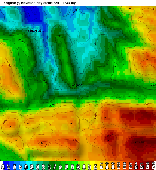
Below is the Elevation map of Longano, which displays elevation range with different colors. Scale of the first map is from 380 to 1345 m (1247 to 4413 ft) with average elevation of 855.9 meters (=2808 ft) [note 1]
These maps also provides idea of topography and contour of this city, they are displayed at different zoom levels. More info about maps, scale and edge coordinates you can find below images.
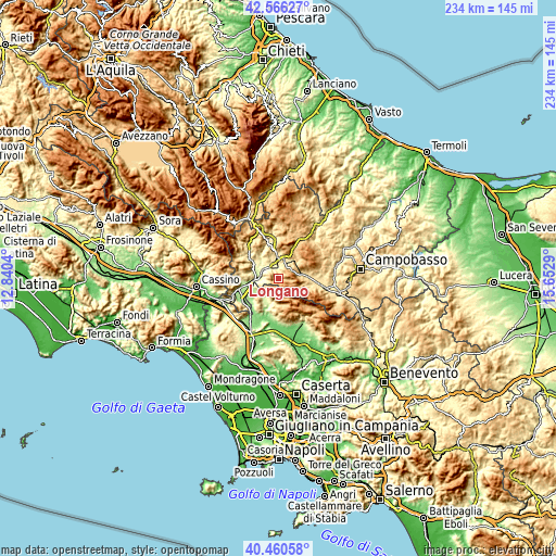
| \ | Map #1 | Topo.Map |
| Scale [m] | 380..1345 m | × |
| Scale [ft] | 1247..4413 ft | × |
| Average | 855.9 m = 2808 ft | × |
| Width | 7.32 km = 4.5 mi | 234.1 km = 145.5 mi |
| Height | 7.32 km = 4.5 mi | 234.1 km = 145.5 mi |
| ↑Max Latitude | 41.554884° | 42.56627° |
| Latitude at center | 41.52199° | 41.52199° |
| ↓Min Latitude | 41.48908° | 40.46058° |
| ← Min Longitude | 14.202705° | 12.8404° |
| Longitude center | 14.24665° | 14.24665° |
| →Max Longitude | 14.290595° | 15.6529° |
Nearby cities:
Cities around Longano sort by population:
• Isernia elevation 479 m
8.3 km,  352°
352°
• Monteroduni 469 m
5.8 km,  270°
270°
• Roccamandolfi 793 m
9.3 km,  108°
108°
• Macchia d'Isernia 316 m
7.7 km,  303°
303°
• Gallo Matese 854 m
6.6 km,  195°
195°
• Fontegreca 321 m
9 km,  215°
215°
• Letino 1010 m
7.7 km,  174°
174°
• Sant'Agapito 567 m
3.2 km,  319°
319°
• Pettoranello del Molise 727 m
6.3 km,  24°
24°
• Gallo 840 m
6.6 km, 195°
• Castelpizzuto 872 m
3.8 km,  91°
91°
• Castelpetroso 842 m
9.3 km,  62°
62°
Multilingual:
 En español:
Longano elevación 671 m.
 En France:
Longano élévation 671 m.


Sources and notes:
- [note 1] Map square and city borders are not equal. Map elevation data is calculated only from area inside that square.
- [src 1] Elevation data from geonames database provided with same terms of usage.
- [src 2] The elevation map of Longano is generated using elevation data from NASA's 3 arcsec (90m) resolution SRTM data.
- [src 3] Base (background) map © OpenStreetMap contributors tiles are generated by Geofabrik and OpenTopoMap.
Copyright & License:
This Longano Elevation Map is licensed under CC BY-SA. You may reuse any part from this page, if you give a proper credit by linking to this URL:
 More info on terms of use page.