Macchia d'Isernia elevation
Macchia d'Isernia (Molise, Provincia di Isernia), Italy elevation is 316 meters and Macchia d'Isernia elevation in feet is 1037 ft above sea level [src 1]. Macchia d'Isernia is a seat of a third-order administrative division (feature code) with elevation that is 6 meters (20 ft) smaller than average city elevation in Italy.
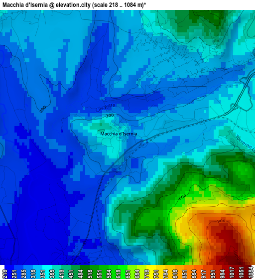
Below is the Elevation map of Macchia d'Isernia, which displays elevation range with different colors. Scale of the first map is from 218 to 1084 m (715 to 3556 ft) with average elevation of 374.3 meters (=1228 ft) [note 1]
These maps also provides idea of topography and contour of this city, they are displayed at different zoom levels. More info about maps, scale and edge coordinates you can find below images.
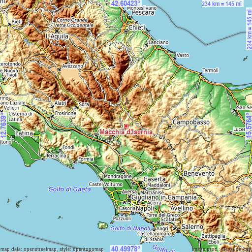
| \ | Map #1 | Topo.Map |
| Scale [m] | 218..1084 m | × |
| Scale [ft] | 715..3556 ft | × |
| Average | 374.3 m = 1228 ft | × |
| Width | 7.31 km = 4.5 mi | 234 km = 145.4 mi |
| Height | 7.31 km = 4.5 mi | 234 km = 145.4 mi |
| ↑Max Latitude | 41.593444° | 42.60423° |
| Latitude at center | 41.56057° | 41.56057° |
| ↓Min Latitude | 41.527679° | 40.49978° |
| ← Min Longitude | 14.126205° | 12.7639° |
| Longitude center | 14.17015° | 14.17015° |
| →Max Longitude | 14.214095° | 15.5764° |
Nearby cities:
Cities around Macchia d'Isernia sort by population:
• Isernia elevation 479 m
6.6 km,  53°
53°
• Taverna Ravindola 240 m
5.6 km,  221°
221°
• Rocchetta a Volturno 550 m
9.9 km,  317°
317°
• Monteroduni 469 m
4.3 km,  173°
173°
• Colli a Volturno 386 m
7.1 km,  308°
308°
• Montaquila 412 m
4.8 km,  275°
275°
• Fornelli 522 m
5.7 km,  334°
334°
• Rocchetta Nuova 555 m
9.9 km, 315°
• Sant'Agapito 567 m
4.7 km,  113°
113°
• Longano 671 m
7.7 km,  123°
123°
• Pettoranello del Molise 727 m
9.1 km,  81°
81°
• Filignano 467 m
9.5 km,  260°
260°
Multilingual:
 En español:
Macchia d'Isernia elevación 316 m.
 En France:
Macchia d'Isernia élévation 316 m.
 Auf Deutsch:
Macchia d'Isernia höhe über dem Meeresspiegel ist 316 m.

Sources and notes:
- [note 1] Map square and city borders are not equal. Map elevation data is calculated only from area inside that square.
- [src 1] Elevation data from geonames database provided with same terms of usage.
- [src 2] The elevation map of Macchia d'Isernia is generated using elevation data from NASA's 3 arcsec (90m) resolution SRTM data.
- [src 3] Base (background) map © OpenStreetMap contributors tiles are generated by Geofabrik and OpenTopoMap.
Copyright & License:
This Macchia d'Isernia Elevation Map is licensed under CC BY-SA. You may reuse any part from this page, if you give a proper credit by linking to this URL:
 More info on terms of use page.