Roè elevation
Roè (Lombardy, Provincia di Brescia), Italy elevation is 235 meters and Roè elevation in feet is 771 ft above sea level [src 1]. Roè is a seat of a third-order administrative division (feature code) with elevation that is 87 meters (285 ft) smaller than average city elevation in Italy.
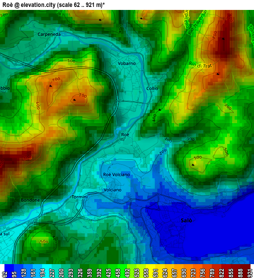
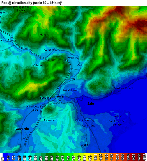
Below is the Elevation map of Roè, which displays elevation range with different colors. Scale of the first map is from 62 to 921 m (203 to 3022 ft) with average elevation of 361.1 meters (=1185 ft) [note 1]
These maps also provides idea of topography and contour of this city, they are displayed at different zoom levels. More info about maps, scale and edge coordinates you can find below images.
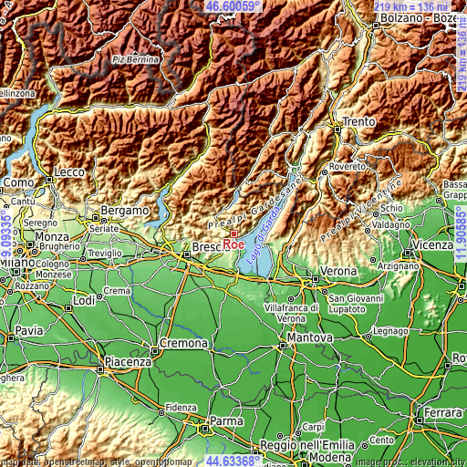
| \ | Map #1 | Map #2 | Topo.Map |
| Scale [m] | 62..921 m | 60..1514 m | × |
| Scale [ft] | 203..3022 ft | 197..4967 ft | × |
| Average | 361.1 m = 1185 ft | 414.2 m = 1359 ft | × |
| Width | 6.83 km = 4.2 mi | 13.67 km = 8.5 mi | 218.7 km = 135.9 mi |
| Height | 6.83 km = 4.2 mi | 13.67 km = 8.5 mi | 218.7 km = 135.9 mi |
| ↑Max Latitude | 45.656484° | 45.687192° | 46.60059° |
| Latitude at center | 45.62576° | 45.62576° | 45.62576° |
| ↓Min Latitude | 45.595019° | 45.564261° | 44.63368° |
| ← Min Longitude | 10.455655° | 10.411709° | 9.09335° |
| Longitude center | 10.4996° | 10.4996° | 10.4996° |
| →Max Longitude | 10.543545° | 10.587491° | 11.90585° |
Nearby cities:
Cities around Roè sort by population:
• Gavardo-Sopraponte elevation 204 m
6 km,  227°
227°
• Salò 79 m
2.7 km,  142°
142°
• Vobarno 254 m
1.8 km,  357°
357°
• Villanuova sul Clisi 216 m
4.7 km, 231°
• Roè Volciano 181 m
1.8 km,  209°
209°
• San Felice del Benaco 98 m
6.4 km, 138°
• Puegnago sul Garda 217 m
6.6 km,  173°
173°
• Gardone Riviera 120 m
5.2 km,  92°
92°
• Raffa 137 m
6.6 km,  159°
159°
• Cunettone-Villa 155 m
4.4 km, 161°
• Castello 229 m
6.3 km, 173°
• San Giacomo 339 m
4 km, 206°
Multilingual:
 En español:
Roè elevación 235 m.
 En France:
Roè élévation 235 m.


Sources and notes:
- [note 1] Map square and city borders are not equal. Map elevation data is calculated only from area inside that square.
- [src 1] Elevation data from geonames database provided with same terms of usage.
- [src 2] The elevation map of Roè is generated using elevation data from NASA's 3 arcsec (90m) resolution SRTM data.
- [src 3] Base (background) map © OpenStreetMap contributors tiles are generated by Geofabrik and OpenTopoMap.
Copyright & License:
This Roè Elevation Map is licensed under CC BY-SA. You may reuse any part from this page, if you give a proper credit by linking to this URL:
 More info on terms of use page.