Gavardo-Sopraponte elevation
Gavardo-Sopraponte (Lombardy, Provincia di Brescia), Italy elevation is 204 meters and Gavardo-Sopraponte elevation in feet is 669 ft above sea level [src 1]. Gavardo-Sopraponte is a seat of a third-order administrative division (feature code) with elevation that is 118 meters (387 ft) smaller than average city elevation in Italy.
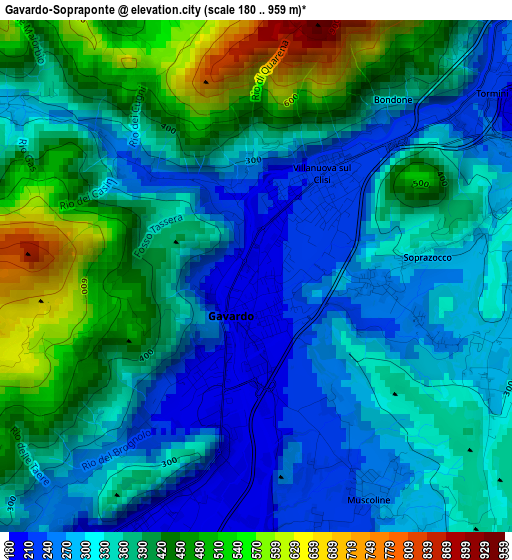
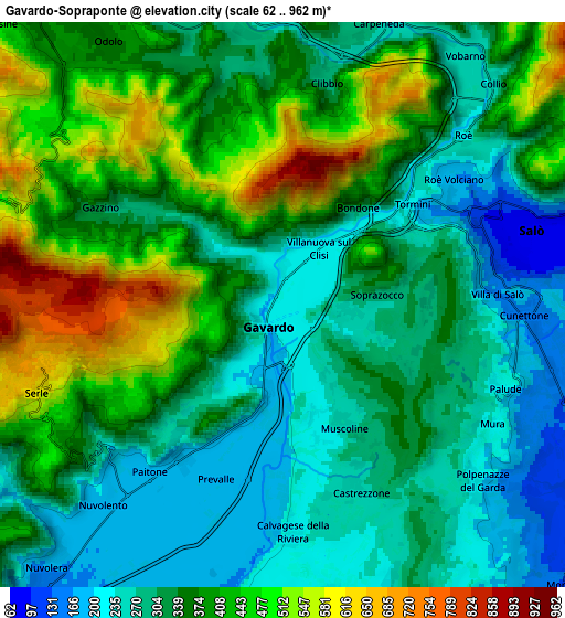
Below is the Elevation map of Gavardo-Sopraponte, which displays elevation range with different colors. Scale of the first map is from 180 to 959 m (591 to 3146 ft) with average elevation of 357.4 meters (=1173 ft) [note 1]
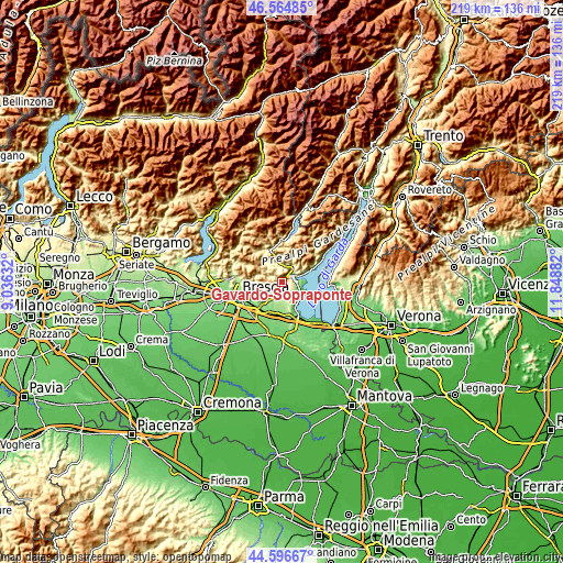
These maps also provides idea of topography and contour of this city, they are displayed at different zoom levels. More info about maps, scale and edge coordinates you can find below images.
| \ | Map #1 | Map #2 | Topo.Map |
| Scale [m] | 180..959 m | 62..962 m | × |
| Scale [ft] | 591..3146 ft | 203..3156 ft | × |
| Average | 357.4 m = 1173 ft | 354.3 m = 1162 ft | × |
| Width | 6.84 km = 4.3 mi | 13.68 km = 8.5 mi | 218.8 km = 136 mi |
| Height | 6.84 km = 4.3 mi | 13.68 km = 8.5 mi | 218.8 km = 136 mi |
| ↑Max Latitude | 45.620134° | 45.650862° | 46.56485° |
| Latitude at center | 45.58939° | 45.58939° | 45.58939° |
| ↓Min Latitude | 45.558629° | 45.527851° | 44.59667° |
| ← Min Longitude | 10.398625° | 10.354679° | 9.03632° |
| Longitude center | 10.44257° | 10.44257° | 10.44257° |
| →Max Longitude | 10.486515° | 10.530461° | 11.84882° |
Nearby cities:
Cities around Gavardo-Sopraponte sort by population:
• Prevalle elevation 192 m
4.5 km,  200°
200°
• Villanuova sul Clisi 216 m
1.4 km,  35°
35°
• Roè Volciano 181 m
4.4 km,  54°
54°
• Muscoline 246 m
3.3 km,  153°
153°
• Paitone 182 m
5.2 km,  217°
217°
• Cunettone-Villa 155 m
5.8 km,  91°
91°
• Castello 229 m
5.6 km,  113°
113°
• Vallio Terme 285 m
4.2 km,  302°
302°
• San Giacomo 339 m
2.7 km,  79°
79°
• Case Nuove 293 m
4.4 km, 301°
• Chiesa 247 m
3.2 km, 152°
• Calvagese della Riviera 221 m
5.6 km,  177°
177°
Multilingual:
 En español:
Gavardo-Sopraponte elevación 204 m.
 En France:
Gavardo élévation 204 m.
 Auf Deutsch:
Gavardo-Sopraponte höhe über dem Meeresspiegel ist 204 m.
 На русском:
Gavardo-Sopraponte высота над уровнем моря 204 м
Sources and notes:
- [note 1] Map square and city borders are not equal. Map elevation data is calculated only from area inside that square.
- [src 1] Elevation data from geonames database provided with same terms of usage.
- [src 2] The elevation map of Gavardo-Sopraponte is generated using elevation data from NASA's 3 arcsec (90m) resolution SRTM data.
- [src 3] Base (background) map © OpenStreetMap contributors tiles are generated by Geofabrik and OpenTopoMap.
Copyright & License:
This Gavardo-Sopraponte Elevation Map is licensed under CC BY-SA. You may reuse any part from this page, if you give a proper credit by linking to this URL:
 More info on terms of use page.