Marentino elevation
Marentino (Piedmont, Torino), Italy elevation is 351 meters and Marentino elevation in feet is 1152 ft above sea level [src 1]. Marentino is a seat of a third-order administrative division (feature code) with elevation that is 29 meters (95 ft) bigger than average city elevation in Italy.
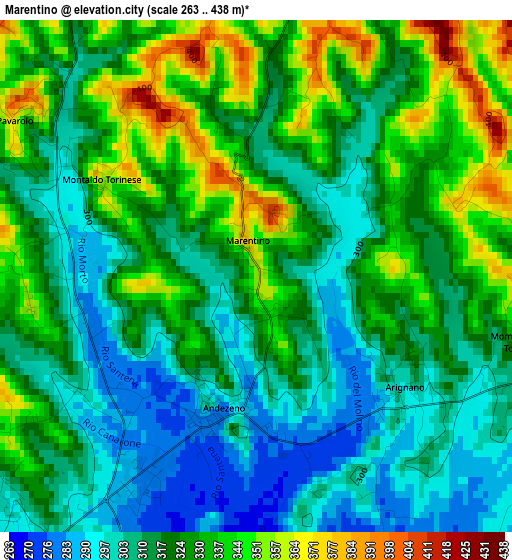
Below is the Elevation map of Marentino, which displays elevation range with different colors. Scale of the first map is from 263 to 438 m (863 to 1437 ft) with average elevation of 321.1 meters (=1053 ft) [note 1]
These maps also provides idea of topography and contour of this city, they are displayed at different zoom levels. More info about maps, scale and edge coordinates you can find below images.
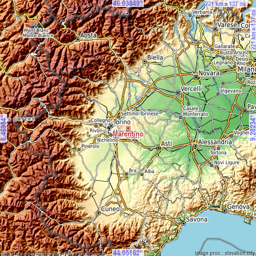
| \ | Map #1 | Topo.Map |
| Scale [m] | 263..438 m | × |
| Scale [ft] | 863..1437 ft | × |
| Average | 321.1 m = 1053 ft | × |
| Width | 6.9 km = 4.3 mi | 220.9 km = 137.3 mi |
| Height | 6.9 km = 4.3 mi | 220.9 km = 137.3 mi |
| ↑Max Latitude | 45.084716° | 46.03849° |
| Latitude at center | 45.05368° | 45.05368° |
| ↓Min Latitude | 45.022627° | 44.05162° |
| ← Min Longitude | 7.832145° | 6.46984° |
| Longitude center | 7.87609° | 7.87609° |
| →Max Longitude | 7.920035° | 9.28234° |
Nearby cities:
Cities around Marentino sort by population:
• Chieri elevation 289 m
6.4 km,  221°
221°
• Baldissero Torinese 464 m
5.2 km,  288°
288°
• Andezeno 278 m
2.4 km,  199°
199°
• Buttigliera d'Asti 296 m
6.9 km,  121°
121°
• Arignano 299 m
2.6 km,  127°
127°
• Pavarolo 328 m
3.2 km,  296°
296°
• Moriondo Torinese 319 m
5.4 km,  108°
108°
• Montaldo Torinese 354 m
2.4 km, 302°
• Sciolze 417 m
4.5 km,  2°
2°
• Mombello di Torino 339 m
3.6 km,  104°
104°
• Moncucco Torinese 396 m
4.7 km,  71°
71°
• Cinzano 480 m
6 km,  39°
39°
Multilingual:
 En español:
Marentino elevación 351 m.
 En France:
Marentino élévation 351 m.
 Auf Deutsch:
Marentino höhe über dem Meeresspiegel ist 351 m.

Sources and notes:
- [note 1] Map square and city borders are not equal. Map elevation data is calculated only from area inside that square.
- [src 1] Elevation data from geonames database provided with same terms of usage.
- [src 2] The elevation map of Marentino is generated using elevation data from NASA's 3 arcsec (90m) resolution SRTM data.
- [src 3] Base (background) map © OpenStreetMap contributors tiles are generated by Geofabrik and OpenTopoMap.
Copyright & License:
This Marentino Elevation Map is licensed under CC BY-SA. You may reuse any part from this page, if you give a proper credit by linking to this URL:
 More info on terms of use page.