Chieri elevation
Chieri (Piedmont, Torino), Italy elevation is 289 meters and Chieri elevation in feet is 948 ft above sea level [src 1]. Chieri is a seat of a third-order administrative division (feature code) with elevation that is 33 meters (108 ft) smaller than average city elevation in Italy.
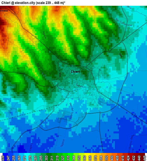
Below is the Elevation map of Chieri, which displays elevation range with different colors. Scale of the first map is from 239 to 448 m (784 to 1470 ft) with average elevation of 295.9 meters (=971 ft) [note 1]
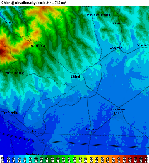
These maps also provides idea of topography and contour of this city, they are displayed at different zoom levels. More info about maps, scale and edge coordinates you can find below images.
| \ | Map #1 | Map #2 | Topo.Map |
| Scale [m] | 239..448 m | 214..712 m | × |
| Scale [ft] | 784..1470 ft | 702..2336 ft | × |
| Average | 295.9 m = 971 ft | 309.9 m = 1017 ft | × |
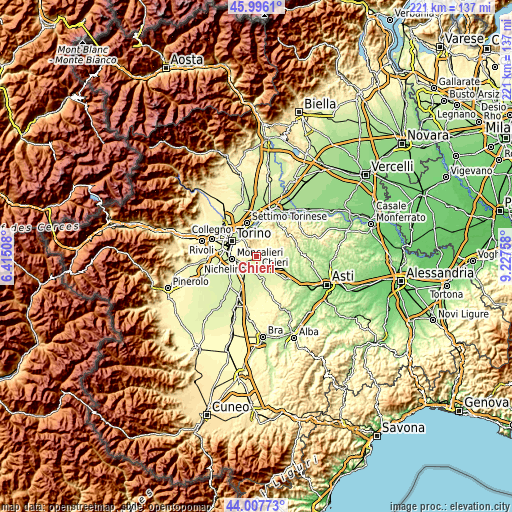
| Width | 6.91 km = 4.3 mi | 13.82 km = 8.6 mi | 221.1 km = 137.4 mi |
| Height | 6.91 km = 4.3 mi | 13.82 km = 8.6 mi | 221.1 km = 137.4 mi |
| ↑Max Latitude | 45.0416° | 45.072643° | 45.9961° |
| Latitude at center | 45.01054° | 45.01054° | 45.01054° |
| ↓Min Latitude | 44.979463° | 44.94837° | 44.00773° |
| ← Min Longitude | 7.777385° | 7.733439° | 6.41508° |
| Longitude center | 7.82133° | 7.82133° | 7.82133° |
| →Max Longitude | 7.865275° | 7.909221° | 9.22758° |
Nearby cities:
Cities around Chieri sort by population:
• Trofarello elevation 250 m
6.6 km,  241°
241°
• Pino Torinese 418 m
4.7 km,  312°
312°
• Cambiano 254 m
5.7 km,  220°
220°
• Riva Presso Chieri 261 m
5.1 km,  126°
126°
• Pecetto 392 m
5.6 km,  278°
278°
• Revigliasco 332 m
7 km,  274°
274°
• Baldissero Torinese 464 m
6.5 km,  354°
354°
• Andezeno 278 m
4.4 km,  53°
53°
• Pessione 253 m
5.3 km,  162°
162°
• Marentino 351 m
6.4 km,  41°
41°
• Pavarolo 328 m
6.4 km,  12°
12°
• Montaldo Torinese 354 m
6.5 km,  20°
20°
Multilingual:
 En español:
Chieri elevación 289 m.
 En France:
Chieri élévation 289 m.


Sources and notes:
- [note 1] Map square and city borders are not equal. Map elevation data is calculated only from area inside that square.
- [src 1] Elevation data from geonames database provided with same terms of usage.
- [src 2] The elevation map of Chieri is generated using elevation data from NASA's 3 arcsec (90m) resolution SRTM data.
- [src 3] Base (background) map © OpenStreetMap contributors tiles are generated by Geofabrik and OpenTopoMap.
Copyright & License:
This Chieri Elevation Map is licensed under CC BY-SA. You may reuse any part from this page, if you give a proper credit by linking to this URL:
 More info on terms of use page.