Sciolze elevation
Sciolze (Piedmont, Torino), Italy elevation is 417 meters and Sciolze elevation in feet is 1368 ft above sea level [src 1]. Sciolze is a seat of a third-order administrative division (feature code) with elevation that is 95 meters (312 ft) bigger than average city elevation in Italy.
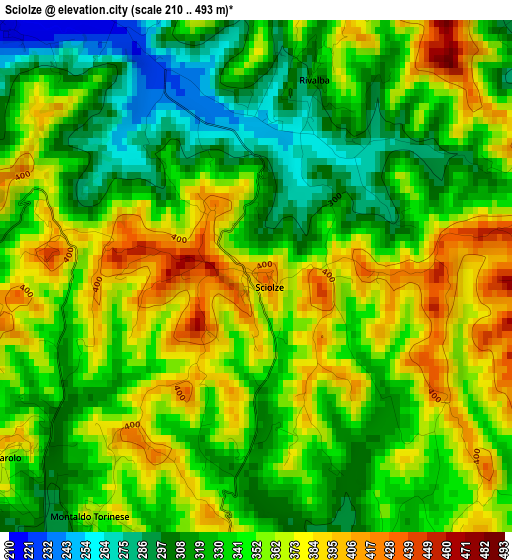
Below is the Elevation map of Sciolze, which displays elevation range with different colors. Scale of the first map is from 210 to 493 m (689 to 1617 ft) with average elevation of 345.1 meters (=1132 ft) [note 1]
These maps also provides idea of topography and contour of this city, they are displayed at different zoom levels. More info about maps, scale and edge coordinates you can find below images.
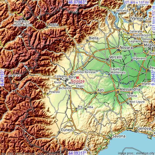
| \ | Map #1 | Topo.Map |
| Scale [m] | 210..493 m | × |
| Scale [ft] | 689..1617 ft | × |
| Average | 345.1 m = 1132 ft | × |
| Width | 6.9 km = 4.3 mi | 220.8 km = 137.2 mi |
| Height | 6.9 km = 4.3 mi | 220.8 km = 137.2 mi |
| ↑Max Latitude | 45.125544° | 46.07863° |
| Latitude at center | 45.09453° | 45.09453° |
| ↓Min Latitude | 45.063499° | 44.09317° |
| ← Min Longitude | 7.834235° | 6.47193° |
| Longitude center | 7.87818° | 7.87818° |
| →Max Longitude | 7.922125° | 9.28443° |
Nearby cities:
Cities around Sciolze sort by population:
• Gassino Torinese elevation 207 m
5.4 km,  315°
315°
• Castiglione Torinese 205 m
6.2 km,  296°
296°
• San Raffaele Cimena 195 m
6.2 km,  338°
338°
• Baldissero Torinese 464 m
5.9 km,  240°
240°
• Casalborgone 203 m
6.3 km,  50°
50°
• Marentino 351 m
4.5 km,  182°
182°
• Pavarolo 328 m
4.3 km,  224°
224°
• Montaldo Torinese 354 m
3.9 km,  214°
214°
• Rivalba 293 m
2.6 km,  17°
17°
• Moncucco Torinese 396 m
5.2 km,  125°
125°
• Berzano di San Pietro 399 m
5.9 km,  90°
90°
• Cinzano 480 m
3.6 km, 88°
Multilingual:
 En español:
Sciolze elevación 417 m.
 En France:
Sciolze élévation 417 m.


Sources and notes:
- [note 1] Map square and city borders are not equal. Map elevation data is calculated only from area inside that square.
- [src 1] Elevation data from geonames database provided with same terms of usage.
- [src 2] The elevation map of Sciolze is generated using elevation data from NASA's 3 arcsec (90m) resolution SRTM data.
- [src 3] Base (background) map © OpenStreetMap contributors tiles are generated by Geofabrik and OpenTopoMap.
Copyright & License:
This Sciolze Elevation Map is licensed under CC BY-SA. You may reuse any part from this page, if you give a proper credit by linking to this URL:
 More info on terms of use page.