Primaluna elevation
Primaluna (Lombardy, Provincia di Lecco), Italy elevation is 565 meters and Primaluna elevation in feet is 1854 ft above sea level [src 1]. Primaluna is a seat of a third-order administrative division (feature code) with elevation that is 243 meters (797 ft) bigger than average city elevation in Italy.
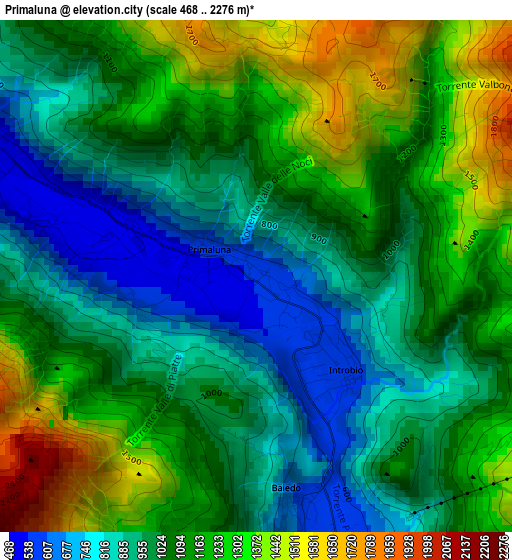
Below is the Elevation map of Primaluna, which displays elevation range with different colors. Scale of the first map is from 468 to 2276 m (1535 to 7467 ft) with average elevation of 1074 meters (=3524 ft) [note 1]
These maps also provides idea of topography and contour of this city, they are displayed at different zoom levels. More info about maps, scale and edge coordinates you can find below images.
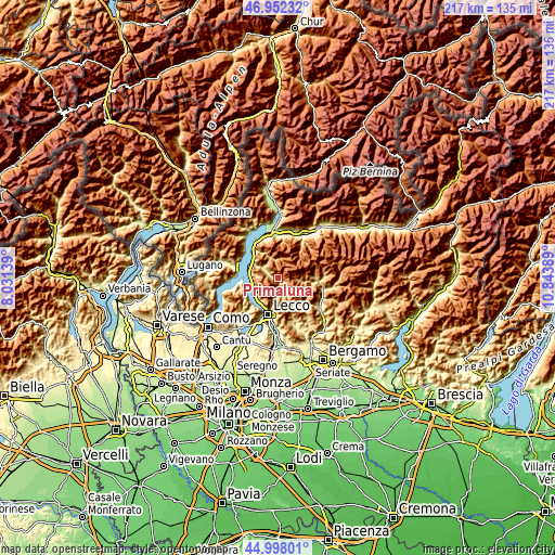
| \ | Map #1 | Topo.Map |
| Scale [m] | 468..2276 m | × |
| Scale [ft] | 1535..7467 ft | × |
| Average | 1074 m = 3524 ft | × |
| Width | 6.79 km = 4.2 mi | 217.3 km = 135 mi |
| Height | 6.79 km = 4.2 mi | 217.3 km = 135 mi |
| ↑Max Latitude | 46.014318° | 46.95232° |
| Latitude at center | 45.98379° | 45.98379° |
| ↓Min Latitude | 45.953246° | 44.99801° |
| ← Min Longitude | 9.393695° | 8.03139° |
| Longitude center | 9.43764° | 9.43764° |
| →Max Longitude | 9.481585° | 10.84389° |
Nearby cities:
Cities around Primaluna sort by population:
• Introbio elevation 573 m
1.5 km,  139°
139°
• Pasturo 614 m
3.6 km,  171°
171°
• Barzio 743 m
5 km,  153°
153°
• Cortenova 470 m
4.5 km,  294°
294°
• Cremeno 777 m
6 km, 154°
• Casargo 813 m
7.3 km,  327°
327°
• Taceno 476 m
7.1 km,  307°
307°
• Moggio 886 m
6.8 km, 146°
• Cassina Valsassina 852 m
6.6 km, 150°
• Margno 738 m
6.8 km,  320°
320°
• Crandola Valsassina 790 m
6.3 km, 314°
• Valtorta 957 m
7.5 km,  95°
95°
Multilingual:
 En español:
Primaluna elevación 565 m.
 En France:
Primaluna élévation 565 m.
 Auf Deutsch:
Primaluna höhe über dem Meeresspiegel ist 565 m.

Sources and notes:
- [note 1] Map square and city borders are not equal. Map elevation data is calculated only from area inside that square.
- [src 1] Elevation data from geonames database provided with same terms of usage.
- [src 2] The elevation map of Primaluna is generated using elevation data from NASA's 3 arcsec (90m) resolution SRTM data.
- [src 3] Base (background) map © OpenStreetMap contributors tiles are generated by Geofabrik and OpenTopoMap.
Copyright & License:
This Primaluna Elevation Map is licensed under CC BY-SA. You may reuse any part from this page, if you give a proper credit by linking to this URL:
 More info on terms of use page.