Moggio elevation
Moggio (Lombardy, Provincia di Lecco), Italy elevation is 886 meters and Moggio elevation in feet is 2907 ft above sea level [src 1]. Moggio is a seat of a third-order administrative division (feature code) with elevation that is 564 meters (1850 ft) bigger than average city elevation in Italy.
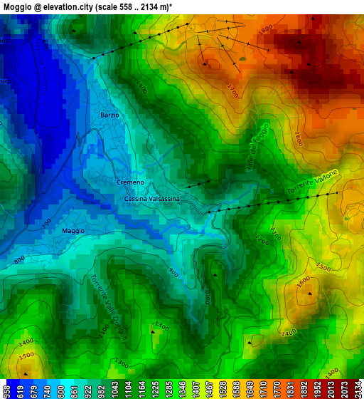
Below is the Elevation map of Moggio, which displays elevation range with different colors. Scale of the first map is from 558 to 2134 m (1831 to 7001 ft) with average elevation of 1180 meters (=3871 ft) [note 1]
These maps also provides idea of topography and contour of this city, they are displayed at different zoom levels. More info about maps, scale and edge coordinates you can find below images.
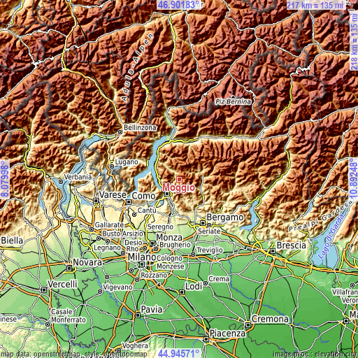
| \ | Map #1 | Topo.Map |
| Scale [m] | 558..2134 m | × |
| Scale [ft] | 1831..7001 ft | × |
| Average | 1180 m = 3871 ft | × |
| Width | 6.8 km = 4.2 mi | 217.5 km = 135.1 mi |
| Height | 6.8 km = 4.2 mi | 217.5 km = 135.1 mi |
| ↑Max Latitude | 45.962946° | 46.90183° |
| Latitude at center | 45.93239° | 45.93239° |
| ↓Min Latitude | 45.901817° | 44.94571° |
| ← Min Longitude | 9.442285° | 8.07998° |
| Longitude center | 9.48623° | 9.48623° |
| →Max Longitude | 9.530175° | 10.89248° |
Nearby cities:
Cities around Moggio sort by population:
• Ballabio elevation 678 m
6.3 km,  230°
230°
• Primaluna 565 m
6.8 km,  326°
326°
• Introbio 573 m
5.4 km, 328°
• Pasturo 614 m
3.9 km,  303°
303°
• Barzio 743 m
1.9 km,  309°
309°
• Cremeno 777 m
1.2 km,  283°
283°
• Taleggio 751 m
7.5 km,  125°
125°
• Cassina Valsassina 852 m
0.6 km,  266°
266°
• Vedeseta 806 m
6.2 km,  138°
138°
• Valtorta 957 m
6.2 km,  37°
37°
• Brumano 896 m
8.7 km,  172°
172°
• Morterone 1047 m
6.4 km,  182°
182°
Multilingual:
 En español:
Moggio elevación 886 m.
 En France:
Moggio élévation 886 m.


Sources and notes:
- [note 1] Map square and city borders are not equal. Map elevation data is calculated only from area inside that square.
- [src 1] Elevation data from geonames database provided with same terms of usage.
- [src 2] The elevation map of Moggio is generated using elevation data from NASA's 3 arcsec (90m) resolution SRTM data.
- [src 3] Base (background) map © OpenStreetMap contributors tiles are generated by Geofabrik and OpenTopoMap.
Copyright & License:
This Moggio Elevation Map is licensed under CC BY-SA. You may reuse any part from this page, if you give a proper credit by linking to this URL:
 More info on terms of use page.