Felitto elevation
Felitto (Campania, Provincia di Salerno), Italy elevation is 276 meters and Felitto elevation in feet is 906 ft above sea level [src 1]. Felitto is a seat of a third-order administrative division (feature code) with elevation that is 46 meters (151 ft) smaller than average city elevation in Italy.
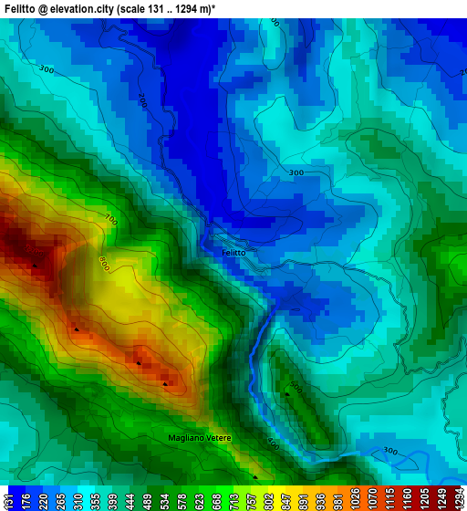
Below is the Elevation map of Felitto, which displays elevation range with different colors. Scale of the first map is from 131 to 1294 m (430 to 4245 ft) with average elevation of 442.7 meters (=1452 ft) [note 1]
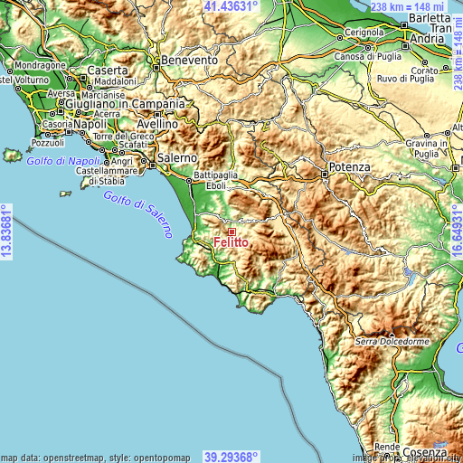
These maps also provides idea of topography and contour of this city, they are displayed at different zoom levels. More info about maps, scale and edge coordinates you can find below images.
| \ | Map #1 | Topo.Map |
| Scale [m] | 131..1294 m | × |
| Scale [ft] | 430..4245 ft | × |
| Average | 442.7 m = 1452 ft | × |
| Width | 7.45 km = 4.6 mi | 238.2 km = 148 mi |
| Height | 7.45 km = 4.6 mi | 238.2 km = 148 mi |
| ↑Max Latitude | 40.406981° | 41.43631° |
| Latitude at center | 40.37351° | 40.37351° |
| ↓Min Latitude | 40.340022° | 39.29368° |
| ← Min Longitude | 15.199115° | 13.83681° |
| Longitude center | 15.24306° | 15.24306° |
| →Max Longitude | 15.287005° | 16.64931° |
Nearby cities:
Cities around Felitto sort by population:
• Roccadaspide elevation 390 m
7.1 km,  321°
321°
• Castel San Lorenzo 332 m
5.4 km,  343°
343°
• Laurino 503 m
8.9 km,  115°
115°
• Bellosguardo 563 m
8 km,  47°
47°
• Roscigno 576 m
9.2 km,  71°
71°
• Aquara 527 m
7.9 km,  6°
6°
• Gioi 688 m
9.6 km,  192°
192°
• Orria 536 m
10.2 km,  216°
216°
• Stio 677 m
7.1 km,  174°
174°
• Monteforte Cilento 584 m
4.2 km,  256°
256°
• Campora 520 m
8.6 km,  151°
151°
• Magliano Vetere 654 m
3 km, 190°
Multilingual:
 En español:
Felitto elevación 276 m.
 En France:
Felitto élévation 276 m.


Sources and notes:
- [note 1] Map square and city borders are not equal. Map elevation data is calculated only from area inside that square.
- [src 1] Elevation data from geonames database provided with same terms of usage.
- [src 2] The elevation map of Felitto is generated using elevation data from NASA's 3 arcsec (90m) resolution SRTM data.
- [src 3] Base (background) map © OpenStreetMap contributors tiles are generated by Geofabrik and OpenTopoMap.
Copyright & License:
This Felitto Elevation Map is licensed under CC BY-SA. You may reuse any part from this page, if you give a proper credit by linking to this URL:
 More info on terms of use page.