Roscigno elevation
Roscigno (Campania, Provincia di Salerno), Italy elevation is 576 meters and Roscigno elevation in feet is 1890 ft above sea level [src 1]. Roscigno is a seat of a third-order administrative division (feature code) with elevation that is 254 meters (833 ft) bigger than average city elevation in Italy.
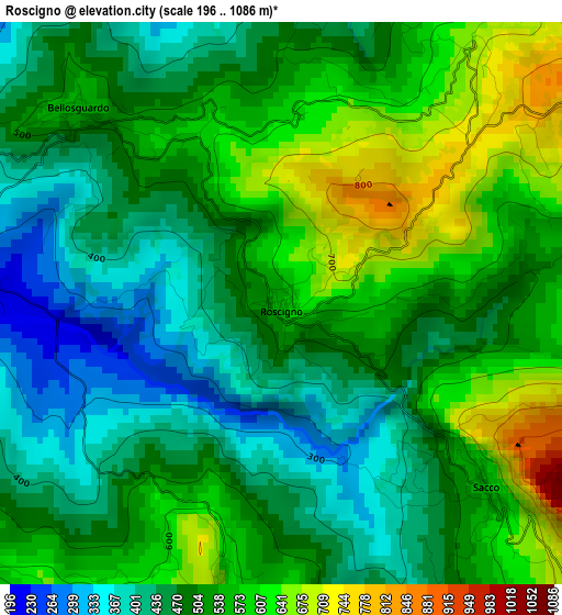
Below is the Elevation map of Roscigno, which displays elevation range with different colors. Scale of the first map is from 196 to 1086 m (643 to 3563 ft) with average elevation of 511.6 meters (=1678 ft) [note 1]
These maps also provides idea of topography and contour of this city, they are displayed at different zoom levels. More info about maps, scale and edge coordinates you can find below images.
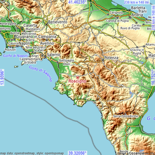
| \ | Map #1 | Topo.Map |
| Scale [m] | 196..1086 m | × |
| Scale [ft] | 643..3563 ft | × |
| Average | 511.6 m = 1678 ft | × |
| Width | 7.44 km = 4.6 mi | 238.1 km = 147.9 mi |
| Height | 7.44 km = 4.6 mi | 238.1 km = 147.9 mi |
| ↑Max Latitude | 40.433428° | 41.46235° |
| Latitude at center | 40.39997° | 40.39997° |
| ↓Min Latitude | 40.366496° | 39.32056° |
| ← Min Longitude | 15.301905° | 13.9396° |
| Longitude center | 15.34585° | 15.34585° |
| →Max Longitude | 15.389795° | 16.7521° |
Nearby cities:
Cities around Roscigno sort by population:
• Castel San Lorenzo elevation 332 m
10.4 km,  282°
282°
• Piaggine 625 m
6.7 km,  156°
156°
• Laurino 503 m
6.8 km,  185°
185°
• Bellosguardo 563 m
3.8 km,  310°
310°
• Aquara 527 m
9.2 km,  302°
302°
• Felitto 276 m
9.2 km,  251°
251°
• Sant'Angelo A Fasanella 494 m
6.4 km,  356°
356°
• San Rufo 652 m
10.7 km,  68°
68°
• Corleto Monforte 629 m
5.1 km,  34°
34°
• Ottati 511 m
7.5 km,  339°
339°
• Sacco 559 m
3.7 km,  133°
133°
• Valle dell'Angelo 651 m
6.5 km, 162°
Multilingual:
 En español:
Roscigno elevación 576 m.
 En France:
Roscigno élévation 576 m.
 Auf Deutsch:
Roscigno höhe über dem Meeresspiegel ist 576 m.

Sources and notes:
- [note 1] Map square and city borders are not equal. Map elevation data is calculated only from area inside that square.
- [src 1] Elevation data from geonames database provided with same terms of usage.
- [src 2] The elevation map of Roscigno is generated using elevation data from NASA's 3 arcsec (90m) resolution SRTM data.
- [src 3] Base (background) map © OpenStreetMap contributors tiles are generated by Geofabrik and OpenTopoMap.
Copyright & License:
This Roscigno Elevation Map is licensed under CC BY-SA. You may reuse any part from this page, if you give a proper credit by linking to this URL:
 More info on terms of use page.