Campora elevation
Campora (Campania, Provincia di Salerno), Italy elevation is 520 meters and Campora elevation in feet is 1706 ft above sea level [src 1]. Campora is a seat of a third-order administrative division (feature code) with elevation that is 198 meters (650 ft) bigger than average city elevation in Italy.
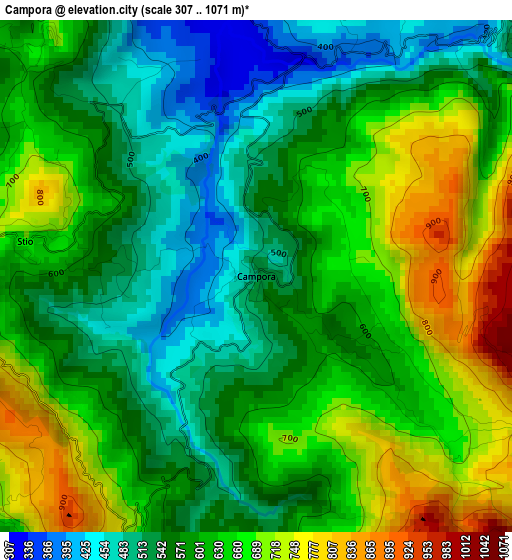
Below is the Elevation map of Campora, which displays elevation range with different colors. Scale of the first map is from 307 to 1071 m (1007 to 3514 ft) with average elevation of 607.8 meters (=1994 ft) [note 1]
These maps also provides idea of topography and contour of this city, they are displayed at different zoom levels. More info about maps, scale and edge coordinates you can find below images.
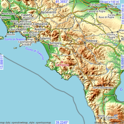
| \ | Map #1 | Topo.Map |
| Scale [m] | 307..1071 m | × |
| Scale [ft] | 1007..3514 ft | × |
| Average | 607.8 m = 1994 ft | × |
| Width | 7.45 km = 4.6 mi | 238.5 km = 148.2 mi |
| Height | 7.45 km = 4.6 mi | 238.5 km = 148.2 mi |
| ↑Max Latitude | 40.338915° | 41.3693° |
| Latitude at center | 40.30541° | 40.30541° |
| ↓Min Latitude | 40.271889° | 39.2245° |
| ← Min Longitude | 15.248415° | 13.88611° |
| Longitude center | 15.29236° | 15.29236° |
| →Max Longitude | 15.336305° | 16.69861° |
Nearby cities:
Cities around Campora sort by population:
• Vallo della Lucania elevation 400 m
8.9 km,  194°
194°
• Novi Velia 578 m
9.2 km,  183°
183°
• Moio della Civitella-Pellare 536 m
6.8 km,  197°
197°
• Piaggine 625 m
8.5 km,  58°
58°
• Laurino 503 m
5.4 km,  45°
45°
• Cannalonga 547 m
6.8 km, 179°
• Felitto 276 m
8.6 km,  331°
331°
• Gioi 688 m
6.5 km,  254°
254°
• Orria 536 m
10.3 km,  266°
266°
• Stio 677 m
3.5 km,  278°
278°
• Valle dell'Angelo 651 m
7.7 km, 56°
• Magliano Vetere 654 m
6.6 km,  314°
314°
Multilingual:
 En español:
Campora elevación 520 m.
 En France:
Campora élévation 520 m.


Sources and notes:
- [note 1] Map square and city borders are not equal. Map elevation data is calculated only from area inside that square.
- [src 1] Elevation data from geonames database provided with same terms of usage.
- [src 2] The elevation map of Campora is generated using elevation data from NASA's 3 arcsec (90m) resolution SRTM data.
- [src 3] Base (background) map © OpenStreetMap contributors tiles are generated by Geofabrik and OpenTopoMap.
Copyright & License:
This Campora Elevation Map is licensed under CC BY-SA. You may reuse any part from this page, if you give a proper credit by linking to this URL:
 More info on terms of use page.