Pasturana elevation
Pasturana (Piedmont, Provincia di Alessandria), Italy elevation is 213 meters and Pasturana elevation in feet is 699 ft above sea level [src 1]. Pasturana is a seat of a third-order administrative division (feature code) with elevation that is 109 meters (358 ft) smaller than average city elevation in Italy.
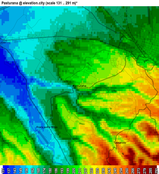
Below is the Elevation map of Pasturana, which displays elevation range with different colors. Scale of the first map is from 131 to 291 m (430 to 955 ft) with average elevation of 192.6 meters (=632 ft) [note 1]
These maps also provides idea of topography and contour of this city, they are displayed at different zoom levels. More info about maps, scale and edge coordinates you can find below images.
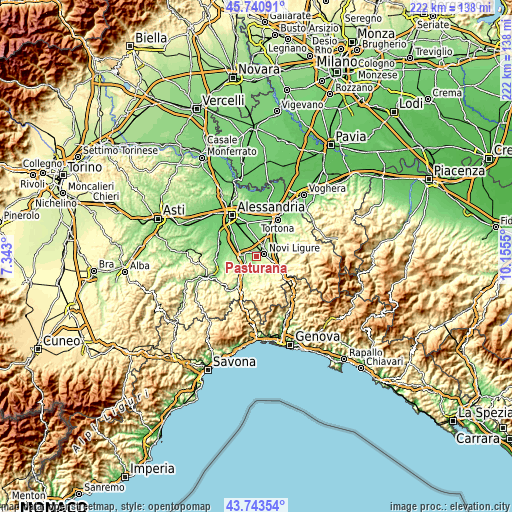
| \ | Map #1 | Topo.Map |
| Scale [m] | 131..291 m | × |
| Scale [ft] | 430..955 ft | × |
| Average | 192.6 m = 632 ft | × |
| Width | 6.94 km = 4.3 mi | 222.1 km = 138 mi |
| Height | 6.94 km = 4.3 mi | 222.1 km = 138 mi |
| ↑Max Latitude | 44.78205° | 45.74091° |
| Latitude at center | 44.75085° | 44.75085° |
| ↓Min Latitude | 44.719633° | 43.74354° |
| ← Min Longitude | 8.705305° | 7.343° |
| Longitude center | 8.74925° | 8.74925° |
| →Max Longitude | 8.793195° | 10.1555° |
Nearby cities:
Cities around Pasturana sort by population:
• Novi Ligure elevation 198 m
3.2 km,  66°
66°
• Serravalle Scrivia 233 m
9 km,  110°
110°
• Pozzolo Formigaro 162 m
6 km,  26°
26°
• Gavi 220 m
8.5 km,  147°
147°
• Basaluzzo 149 m
4 km,  299°
299°
• Castelletto d'Orba 209 m
8.2 km,  205°
205°
• Predosa 138 m
7.4 km,  269°
269°
• Capriata d'Orba 178 m
5.3 km,  240°
240°
• San Cristoforo 288 m
6.4 km,  179°
179°
• Tassarolo 216 m
3.1 km, 145°
• Francavilla Bisio 163 m
2.3 km,  218°
218°
• Fresonara 143 m
6.1 km,  305°
305°
Multilingual:
 En español:
Pasturana elevación 213 m.
 En France:
Pasturana élévation 213 m.
 Auf Deutsch:
Pasturana höhe über dem Meeresspiegel ist 213 m.

Sources and notes:
- [note 1] Map square and city borders are not equal. Map elevation data is calculated only from area inside that square.
- [src 1] Elevation data from geonames database provided with same terms of usage.
- [src 2] The elevation map of Pasturana is generated using elevation data from NASA's 3 arcsec (90m) resolution SRTM data.
- [src 3] Base (background) map © OpenStreetMap contributors tiles are generated by Geofabrik and OpenTopoMap.
Copyright & License:
This Pasturana Elevation Map is licensed under CC BY-SA. You may reuse any part from this page, if you give a proper credit by linking to this URL:
 More info on terms of use page.