Gavi elevation
Gavi (Piedmont, Provincia di Alessandria), Italy elevation is 220 meters and Gavi elevation in feet is 722 ft above sea level [src 1]. Gavi is a seat of a third-order administrative division (feature code) with elevation that is 102 meters (335 ft) smaller than average city elevation in Italy.
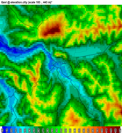
Below is the Elevation map of Gavi, which displays elevation range with different colors. Scale of the first map is from 183 to 443 m (600 to 1453 ft) with average elevation of 287 meters (=942 ft) [note 1]
These maps also provides idea of topography and contour of this city, they are displayed at different zoom levels. More info about maps, scale and edge coordinates you can find below images.
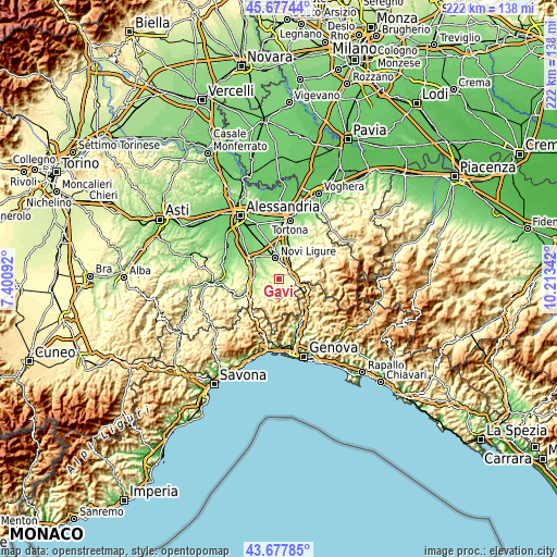
| \ | Map #1 | Topo.Map |
| Scale [m] | 183..443 m | × |
| Scale [ft] | 600..1453 ft | × |
| Average | 287 m = 942 ft | × |
| Width | 6.95 km = 4.3 mi | 222.3 km = 138.1 mi |
| Height | 6.95 km = 4.3 mi | 222.3 km = 138.1 mi |
| ↑Max Latitude | 44.717505° | 45.67744° |
| Latitude at center | 44.68627° | 44.68627° |
| ↓Min Latitude | 44.655018° | 43.67785° |
| ← Min Longitude | 8.763225° | 7.40092° |
| Longitude center | 8.80717° | 8.80717° |
| →Max Longitude | 8.851115° | 10.21342° |
Nearby cities:
Cities around Gavi sort by population:
• Serravalle Scrivia elevation 233 m
5.6 km,  43°
43°
• Arquata Scrivia 246 m
6.3 km,  87°
87°
• Stazzano 221 m
6.7 km,  46°
46°
• Vignole Borbera 245 m
7 km,  69°
69°
• Bosio 345 m
4.2 km,  195°
195°
• San Cristoforo 288 m
4.6 km,  279°
279°
• Voltaggio 342 m
7.8 km,  158°
158°
• Mornese 368 m
6.6 km,  217°
217°
• Tassarolo 216 m
5.4 km,  328°
328°
• Carrosio 272 m
3.7 km,  148°
148°
• Montaldeo 311 m
6.5 km,  250°
250°
• Parodi Ligure 352 m
4.3 km,  244°
244°
Multilingual:
 En español:
Gavi elevación 220 m.
 En France:
Gavi élévation 220 m.


Sources and notes:
- [note 1] Map square and city borders are not equal. Map elevation data is calculated only from area inside that square.
- [src 1] Elevation data from geonames database provided with same terms of usage.
- [src 2] The elevation map of Gavi is generated using elevation data from NASA's 3 arcsec (90m) resolution SRTM data.
- [src 3] Base (background) map © OpenStreetMap contributors tiles are generated by Geofabrik and OpenTopoMap.
Copyright & License:
This Gavi Elevation Map is licensed under CC BY-SA. You may reuse any part from this page, if you give a proper credit by linking to this URL:
 More info on terms of use page.