Fresonara elevation
Fresonara (Piedmont, Provincia di Alessandria), Italy elevation is 143 meters and Fresonara elevation in feet is 469 ft above sea level [src 1]. Fresonara is a seat of a third-order administrative division (feature code) with elevation that is 179 meters (587 ft) smaller than average city elevation in Italy.
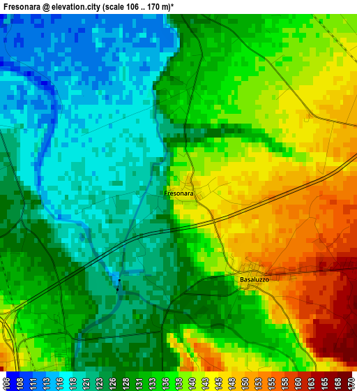
Below is the Elevation map of Fresonara, which displays elevation range with different colors. Scale of the first map is from 106 to 170 m (348 to 558 ft) with average elevation of 132.6 meters (=435 ft) [note 1]
These maps also provides idea of topography and contour of this city, they are displayed at different zoom levels. More info about maps, scale and edge coordinates you can find below images.
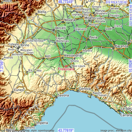
| \ | Map #1 | Topo.Map |
| Scale [m] | 106..170 m | × |
| Scale [ft] | 348..558 ft | × |
| Average | 132.6 m = 435 ft | × |
| Width | 6.94 km = 4.3 mi | 222 km = 137.9 mi |
| Height | 6.94 km = 4.3 mi | 222 km = 137.9 mi |
| ↑Max Latitude | 44.814133° | 45.77245° |
| Latitude at center | 44.78295° | 44.78295° |
| ↓Min Latitude | 44.75175° | 43.77619° |
| ← Min Longitude | 8.642205° | 7.2799° |
| Longitude center | 8.68615° | 8.68615° |
| →Max Longitude | 8.730095° | 10.0924° |
Nearby cities:
Cities around Fresonara sort by population:
• Novi Ligure elevation 198 m
8.3 km,  105°
105°
• Pozzolo Formigaro 162 m
7.9 km,  76°
76°
• Basaluzzo 149 m
2.2 km,  136°
136°
• Frugarolo 118 m
6.3 km,  356°
356°
• Bosco Marengo 123 m
4.6 km,  353°
353°
• Predosa 138 m
4.3 km,  213°
213°
• Capriata d'Orba 178 m
6.1 km,  176°
176°
• Sezzadio 123 m
9 km,  271°
271°
• Pasturana 213 m
6.1 km,  125°
125°
• Casal Cermelli 106 m
7.5 km,  320°
320°
• Francavilla Bisio 163 m
6.4 km,  146°
146°
• Castelspina 115 m
8.5 km,  287°
287°
Multilingual:
 En español:
Fresonara elevación 143 m.
 En France:
Fresonara élévation 143 m.
 Auf Deutsch:
Fresonara höhe über dem Meeresspiegel ist 143 m.

Sources and notes:
- [note 1] Map square and city borders are not equal. Map elevation data is calculated only from area inside that square.
- [src 1] Elevation data from geonames database provided with same terms of usage.
- [src 2] The elevation map of Fresonara is generated using elevation data from NASA's 3 arcsec (90m) resolution SRTM data.
- [src 3] Base (background) map © OpenStreetMap contributors tiles are generated by Geofabrik and OpenTopoMap.
Copyright & License:
This Fresonara Elevation Map is licensed under CC BY-SA. You may reuse any part from this page, if you give a proper credit by linking to this URL:
 More info on terms of use page.