Serralunga d'Alba elevation
Serralunga d'Alba (Piedmont, Provincia di Cuneo), Italy elevation is 385 meters and Serralunga d'Alba elevation in feet is 1263 ft above sea level [src 1]. Serralunga d'Alba is a seat of a third-order administrative division (feature code) with elevation that is 63 meters (207 ft) bigger than average city elevation in Italy.
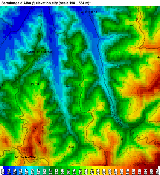
Below is the Elevation map of Serralunga d'Alba, which displays elevation range with different colors. Scale of the first map is from 198 to 584 m (650 to 1916 ft) with average elevation of 353.7 meters (=1160 ft) [note 1]
These maps also provides idea of topography and contour of this city, they are displayed at different zoom levels. More info about maps, scale and edge coordinates you can find below images.
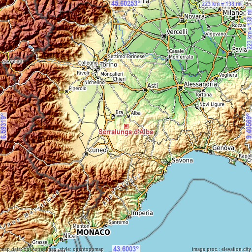
| \ | Map #1 | Topo.Map |
| Scale [m] | 198..584 m | × |
| Scale [ft] | 650..1916 ft | × |
| Average | 353.7 m = 1160 ft | × |
| Width | 6.96 km = 4.3 mi | 222.6 km = 138.3 mi |
| Height | 6.96 km = 4.3 mi | 222.6 km = 138.3 mi |
| ↑Max Latitude | 44.641316° | 45.60253° |
| Latitude at center | 44.61004° | 44.61004° |
| ↓Min Latitude | 44.578747° | 43.6003° |
| ← Min Longitude | 7.955495° | 6.59319° |
| Longitude center | 7.99944° | 7.99944° |
| →Max Longitude | 8.043385° | 9.40569° |
Nearby cities:
Cities around Serralunga d'Alba sort by population:
• Grinzane Cavour elevation 269 m
4.8 km,  355°
355°
• Monforte d'Alba 471 m
3.9 km,  219°
219°
• Diano d'Alba 446 m
5.2 km,  24°
24°
• Rodello 528 m
5 km,  65°
65°
• Novello 438 m
6.3 km,  247°
247°
• Barolo 298 m
4.5 km,  271°
271°
• Montelupo Albese 553 m
4 km, 71°
• Castiglione Falletto 337 m
2.4 km,  306°
306°
• Sinio 327 m
1.9 km,  123°
123°
• Roddino 594 m
4.3 km,  158°
158°
• Albaretto della Torre 666 m
5.4 km,  106°
106°
• Cissone 639 m
5.8 km,  154°
154°
Multilingual:
 En español:
Serralunga d'Alba elevación 385 m.
 En France:
Serralunga d'Alba élévation 385 m.
 Auf Deutsch:
Serralunga d'Alba höhe über dem Meeresspiegel ist 385 m.

Sources and notes:
- [note 1] Map square and city borders are not equal. Map elevation data is calculated only from area inside that square.
- [src 1] Elevation data from geonames database provided with same terms of usage.
- [src 2] The elevation map of Serralunga d'Alba is generated using elevation data from NASA's 3 arcsec (90m) resolution SRTM data.
- [src 3] Base (background) map © OpenStreetMap contributors tiles are generated by Geofabrik and OpenTopoMap.
Copyright & License:
This Serralunga d'Alba Elevation Map is licensed under CC BY-SA. You may reuse any part from this page, if you give a proper credit by linking to this URL:
 More info on terms of use page.