Roddino elevation
Roddino (Piedmont, Provincia di Cuneo), Italy elevation is 594 meters and Roddino elevation in feet is 1949 ft above sea level [src 1]. Roddino is a seat of a third-order administrative division (feature code) with elevation that is 272 meters (892 ft) bigger than average city elevation in Italy.
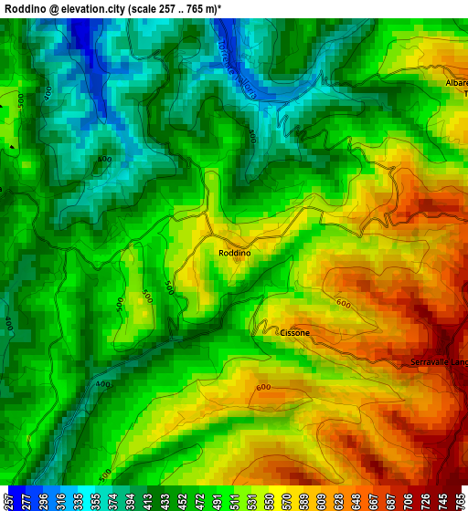
Below is the Elevation map of Roddino, which displays elevation range with different colors. Scale of the first map is from 257 to 765 m (843 to 2510 ft) with average elevation of 497.6 meters (=1633 ft) [note 1]
These maps also provides idea of topography and contour of this city, they are displayed at different zoom levels. More info about maps, scale and edge coordinates you can find below images.
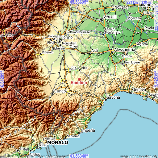
| \ | Map #1 | Topo.Map |
| Scale [m] | 257..765 m | × |
| Scale [ft] | 843..2510 ft | × |
| Average | 497.6 m = 1633 ft | × |
| Width | 6.96 km = 4.3 mi | 222.8 km = 138.4 mi |
| Height | 6.96 km = 4.3 mi | 222.8 km = 138.4 mi |
| ↑Max Latitude | 44.605136° | 45.56695° |
| Latitude at center | 44.57384° | 44.57384° |
| ↓Min Latitude | 44.542527° | 43.56348° |
| ← Min Longitude | 7.975195° | 6.61289° |
| Longitude center | 8.01914° | 8.01914° |
| →Max Longitude | 8.063085° | 9.42539° |
Nearby cities:
Cities around Roddino sort by population:
• Monforte d'Alba elevation 471 m
4.2 km,  283°
283°
• Rodello 528 m
6.8 km,  26°
26°
• Bossolasco 749 m
5.6 km,  154°
154°
• Montelupo Albese 553 m
5.7 km,  22°
22°
• Castiglione Falletto 337 m
6.4 km,  327°
327°
• Somano 502 m
4.4 km,  191°
191°
• Serralunga d'Alba 385 m
4.3 km,  338°
338°
• Serravalle Langhe 738 m
3.5 km,  115°
115°
• Sinio 327 m
2.9 km,  1°
1°
• Albaretto della Torre 666 m
4.4 km,  55°
55°
• Cerreto Langhe 666 m
6.2 km,  88°
88°
• Cissone 639 m
1.5 km,  143°
143°
Multilingual:
 En español:
Roddino elevación 594 m.
 En France:
Roddino élévation 594 m.


Sources and notes:
- [note 1] Map square and city borders are not equal. Map elevation data is calculated only from area inside that square.
- [src 1] Elevation data from geonames database provided with same terms of usage.
- [src 2] The elevation map of Roddino is generated using elevation data from NASA's 3 arcsec (90m) resolution SRTM data.
- [src 3] Base (background) map © OpenStreetMap contributors tiles are generated by Geofabrik and OpenTopoMap.
Copyright & License:
This Roddino Elevation Map is licensed under CC BY-SA. You may reuse any part from this page, if you give a proper credit by linking to this URL:
 More info on terms of use page.