Cerreto Langhe elevation
Cerreto Langhe (Piedmont, Provincia di Cuneo), Italy elevation is 666 meters and Cerreto Langhe elevation in feet is 2185 ft above sea level [src 1]. Cerreto Langhe is a seat of a third-order administrative division (feature code) with elevation that is 344 meters (1129 ft) bigger than average city elevation in Italy.
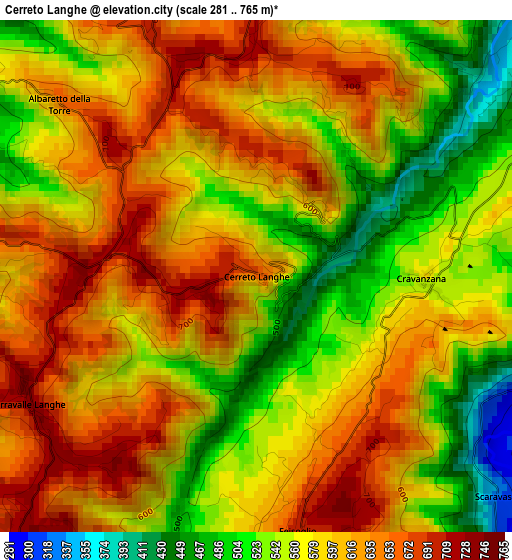
Below is the Elevation map of Cerreto Langhe, which displays elevation range with different colors. Scale of the first map is from 281 to 765 m (922 to 2510 ft) with average elevation of 586.2 meters (=1923 ft) [note 1]
These maps also provides idea of topography and contour of this city, they are displayed at different zoom levels. More info about maps, scale and edge coordinates you can find below images.
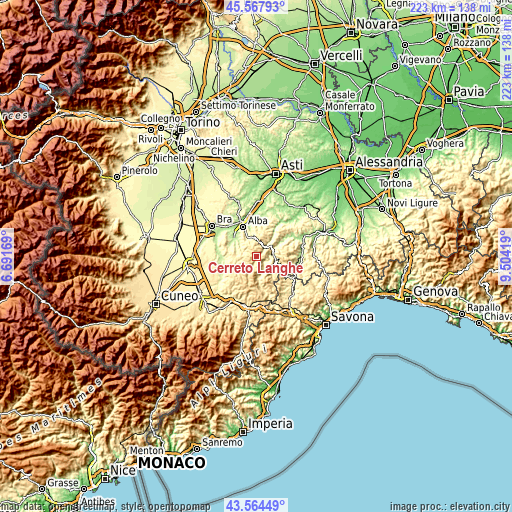
| \ | Map #1 | Topo.Map |
| Scale [m] | 281..765 m | × |
| Scale [ft] | 922..2510 ft | × |
| Average | 586.2 m = 1923 ft | × |
| Width | 6.96 km = 4.3 mi | 222.8 km = 138.4 mi |
| Height | 6.96 km = 4.3 mi | 222.8 km = 138.4 mi |
| ↑Max Latitude | 44.606135° | 45.56793° |
| Latitude at center | 44.57484° | 44.57484° |
| ↓Min Latitude | 44.543528° | 43.56449° |
| ← Min Longitude | 8.053995° | 6.69169° |
| Longitude center | 8.09794° | 8.09794° |
| →Max Longitude | 8.141885° | 9.50419° |
Nearby cities:
Cities around Cerreto Langhe sort by population:
• Feisoglio elevation 699 m
3.5 km,  170°
170°
• Cravanzana 563 m
2.3 km,  90°
90°
• Benevello 655 m
6.1 km,  5°
5°
• Serravalle Langhe 738 m
3.5 km,  241°
241°
• Lequio Berria 714 m
3.4 km,  0°
0°
• Albaretto della Torre 666 m
3.6 km,  312°
312°
• Torre Bormida 377 m
4.7 km,  106°
106°
• Cissone 639 m
5.5 km,  256°
256°
• Levice 516 m
6.1 km,  131°
131°
• Bosia 481 m
5 km,  51°
51°
• Borgomale 454 m
5.7 km,  28°
28°
• Arguello 619 m
1.3 km, 49°
Multilingual:
 En español:
Cerreto Langhe elevación 666 m.
 En France:
Cerreto Langhe élévation 666 m.
 Auf Deutsch:
Cerreto Langhe höhe über dem Meeresspiegel ist 666 m.

Sources and notes:
- [note 1] Map square and city borders are not equal. Map elevation data is calculated only from area inside that square.
- [src 1] Elevation data from geonames database provided with same terms of usage.
- [src 2] The elevation map of Cerreto Langhe is generated using elevation data from NASA's 3 arcsec (90m) resolution SRTM data.
- [src 3] Base (background) map © OpenStreetMap contributors tiles are generated by Geofabrik and OpenTopoMap.
Copyright & License:
This Cerreto Langhe Elevation Map is licensed under CC BY-SA. You may reuse any part from this page, if you give a proper credit by linking to this URL:
 More info on terms of use page.