Alto elevation
Alto (Piedmont, Provincia di Cuneo), Italy elevation is 647 meters and Alto elevation in feet is 2123 ft above sea level [src 1]. Alto is a seat of a third-order administrative division (feature code) with elevation that is 325 meters (1066 ft) bigger than average city elevation in Italy.
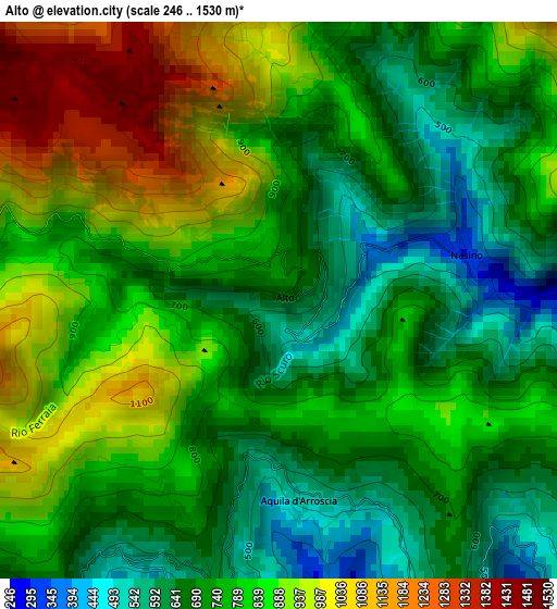
Below is the Elevation map of Alto, which displays elevation range with different colors. Scale of the first map is from 246 to 1530 m (807 to 5020 ft) with average elevation of 787 meters (=2582 ft) [note 1]
These maps also provides idea of topography and contour of this city, they are displayed at different zoom levels. More info about maps, scale and edge coordinates you can find below images.
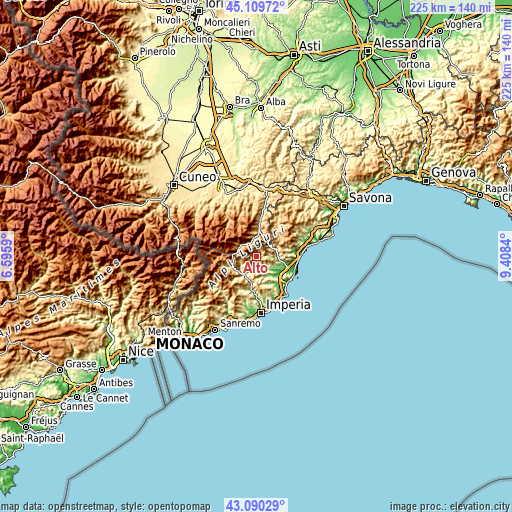
| \ | Map #1 | Topo.Map |
| Scale [m] | 246..1530 m | × |
| Scale [ft] | 807..5020 ft | × |
| Average | 787 m = 2582 ft | × |
| Width | 7.02 km = 4.4 mi | 224.5 km = 139.5 mi |
| Height | 7.02 km = 4.4 mi | 224.5 km = 139.5 mi |
| ↑Max Latitude | 44.140175° | 45.10972° |
| Latitude at center | 44.10863° | 44.10863° |
| ↓Min Latitude | 44.077068° | 43.09029° |
| ← Min Longitude | 7.958205° | 6.5959° |
| Longitude center | 8.00215° | 8.00215° |
| →Max Longitude | 8.046095° | 9.4084° |
Nearby cities:
Cities around Alto sort by population:
• Ormea elevation 695 m
7.9 km,  311°
311°
• Vendone 360 m
6.5 km,  122°
122°
• Castelbianco 373 m
5.9 km,  83°
83°
• Vessalico 192 m
7.8 km,  205°
205°
• Onzo 433 m
5.9 km,  136°
136°
• Borgo di Ranzo 122 m
5.5 km,  169°
169°
• Erli 326 m
8.7 km,  68°
68°
• Nasino-Borgo 304 m
2.5 km, 76°
• Caprauna 951 m
3.9 km,  282°
282°
• Aquila di Arroscia 524 m
2.5 km, 174°
• Armo 600 m
7.3 km,  251°
251°
• Borghetto d'Arroscia 163 m
6 km,  196°
196°
Multilingual:
 En español:
Alto elevación 647 m.
 En France:
Alto élévation 647 m.


Sources and notes:
- [note 1] Map square and city borders are not equal. Map elevation data is calculated only from area inside that square.
- [src 1] Elevation data from geonames database provided with same terms of usage.
- [src 2] The elevation map of Alto is generated using elevation data from NASA's 3 arcsec (90m) resolution SRTM data.
- [src 3] Base (background) map © OpenStreetMap contributors tiles are generated by Geofabrik and OpenTopoMap.
Copyright & License:
This Alto Elevation Map is licensed under CC BY-SA. You may reuse any part from this page, if you give a proper credit by linking to this URL:
 More info on terms of use page.