Armo elevation
Armo (Liguria, Provincia di Imperia), Italy elevation is 600 meters and Armo elevation in feet is 1969 ft above sea level [src 1]. Armo is a seat of a third-order administrative division (feature code) with elevation that is 278 meters (912 ft) bigger than average city elevation in Italy.
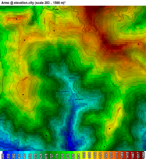
Below is the Elevation map of Armo, which displays elevation range with different colors. Scale of the first map is from 283 to 1566 m (928 to 5138 ft) with average elevation of 887.5 meters (=2912 ft) [note 1]
These maps also provides idea of topography and contour of this city, they are displayed at different zoom levels. More info about maps, scale and edge coordinates you can find below images.
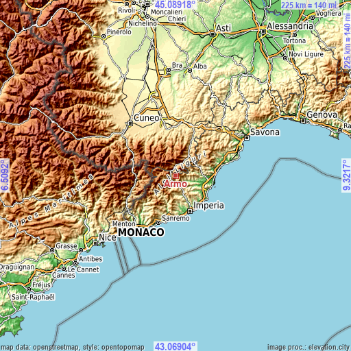
| \ | Map #1 | Topo.Map |
| Scale [m] | 283..1566 m | × |
| Scale [ft] | 928..5138 ft | × |
| Average | 887.5 m = 2912 ft | × |
| Width | 7.02 km = 4.4 mi | 224.6 km = 139.6 mi |
| Height | 7.02 km = 4.4 mi | 224.6 km = 139.6 mi |
| ↑Max Latitude | 44.119286° | 45.08918° |
| Latitude at center | 44.08773° | 44.08773° |
| ↓Min Latitude | 44.056157° | 43.06904° |
| ← Min Longitude | 7.871505° | 6.5092° |
| Longitude center | 7.91545° | 7.91545° |
| →Max Longitude | 7.959395° | 9.3217° |
Nearby cities:
Cities around Armo sort by population:
• Ormea elevation 695 m
7.6 km,  7°
7°
• Pieve di Teco 263 m
4.5 km,  179°
179°
• Pornassio 677 m
4.1 km,  242°
242°
• Rezzo 554 m
8.2 km,  205°
205°
• Cosio di Arroscia 749 m
6.7 km,  260°
260°
• Vessalico 192 m
5.9 km,  142°
142°
• Borgo di Ranzo 122 m
8.5 km,  111°
111°
• Montegrosso Pian Latte 747 m
8.3 km,  253°
253°
• Caprauna 951 m
4.5 km,  45°
45°
• Aquila di Arroscia 524 m
7.2 km,  91°
91°
• Alto 647 m
7.3 km,  71°
71°
• Borghetto d'Arroscia 163 m
6.3 km,  123°
123°
Multilingual:
 En español:
Armo elevación 600 m.
 En France:
Armo élévation 600 m.


Sources and notes:
- [note 1] Map square and city borders are not equal. Map elevation data is calculated only from area inside that square.
- [src 1] Elevation data from geonames database provided with same terms of usage.
- [src 2] The elevation map of Armo is generated using elevation data from NASA's 3 arcsec (90m) resolution SRTM data.
- [src 3] Base (background) map © OpenStreetMap contributors tiles are generated by Geofabrik and OpenTopoMap.
Copyright & License:
This Armo Elevation Map is licensed under CC BY-SA. You may reuse any part from this page, if you give a proper credit by linking to this URL:
 More info on terms of use page.