Onzo elevation
Onzo (Liguria, Provincia di Savona), Italy elevation is 433 meters and Onzo elevation in feet is 1421 ft above sea level [src 1]. Onzo is a seat of a third-order administrative division (feature code) with elevation that is 111 meters (364 ft) bigger than average city elevation in Italy.
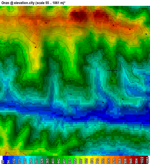
Below is the Elevation map of Onzo, which displays elevation range with different colors. Scale of the first map is from 55 to 1061 m (180 to 3481 ft) with average elevation of 416 meters (=1365 ft) [note 1]
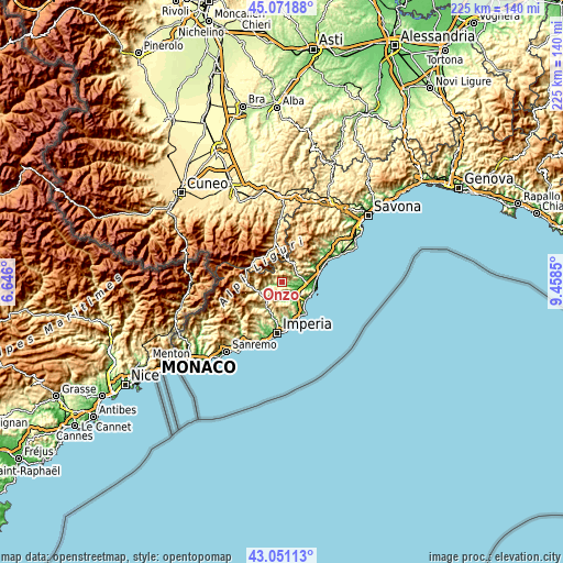
These maps also provides idea of topography and contour of this city, they are displayed at different zoom levels. More info about maps, scale and edge coordinates you can find below images.
| \ | Map #1 | Topo.Map |
| Scale [m] | 55..1061 m | × |
| Scale [ft] | 180..3481 ft | × |
| Average | 416 m = 1365 ft | × |
| Width | 7.02 km = 4.4 mi | 224.7 km = 139.6 mi |
| Height | 7.02 km = 4.4 mi | 224.7 km = 139.6 mi |
| ↑Max Latitude | 44.101696° | 45.07188° |
| Latitude at center | 44.07013° | 44.07013° |
| ↓Min Latitude | 44.038547° | 43.05113° |
| ← Min Longitude | 8.008305° | 6.646° |
| Longitude center | 8.05225° | 8.05225° |
| →Max Longitude | 8.096195° | 9.4585° |
Nearby cities:
Cities around Onzo sort by population:
• Villafranca elevation 55 m
5.9 km,  134°
134°
• Ortovero 62 m
4.2 km,  115°
115°
• Garlenda 64 m
5.4 km,  139°
139°
• Arnasco 293 m
4.5 km,  78°
78°
• Vendone 360 m
1.7 km,  63°
63°
• Castelbianco 373 m
5.2 km,  20°
20°
• Casanova Lerrone 303 m
4.2 km,  185°
185°
• Borgo di Ranzo 122 m
3.2 km,  248°
248°
• Chiesa 264 m
4.6 km, 79°
• Nasino-Borgo 304 m
5.1 km,  341°
341°
• Aquila di Arroscia 524 m
4.1 km,  295°
295°
• Borghetto d'Arroscia 163 m
5.9 km,  255°
255°
Multilingual:
 En español:
Onzo elevación 433 m.
 En France:
Onzo élévation 433 m.


Sources and notes:
- [note 1] Map square and city borders are not equal. Map elevation data is calculated only from area inside that square.
- [src 1] Elevation data from geonames database provided with same terms of usage.
- [src 2] The elevation map of Onzo is generated using elevation data from NASA's 3 arcsec (90m) resolution SRTM data.
- [src 3] Base (background) map © OpenStreetMap contributors tiles are generated by Geofabrik and OpenTopoMap.
Copyright & License:
This Onzo Elevation Map is licensed under CC BY-SA. You may reuse any part from this page, if you give a proper credit by linking to this URL:
 More info on terms of use page.