Graffignana elevation
Graffignana (Lombardy, Provincia di Lodi), Italy elevation is 69 meters and Graffignana elevation in feet is 226 ft above sea level [src 1]. Graffignana is a seat of a third-order administrative division (feature code) with elevation that is 253 meters (830 ft) smaller than average city elevation in Italy.
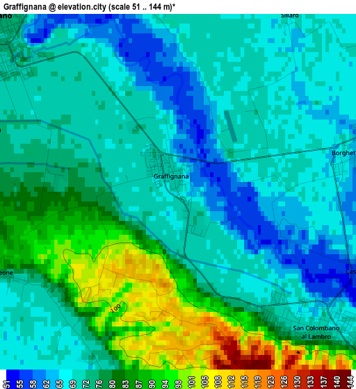
Below is the Elevation map of Graffignana, which displays elevation range with different colors. Scale of the first map is from 51 to 144 m (167 to 472 ft) with average elevation of 75.2 meters (=247 ft) [note 1]
These maps also provides idea of topography and contour of this city, they are displayed at different zoom levels. More info about maps, scale and edge coordinates you can find below images.
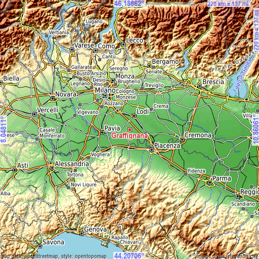
| \ | Map #1 | Topo.Map |
| Scale [m] | 51..144 m | × |
| Scale [ft] | 167..472 ft | × |
| Average | 75.2 m = 247 ft | × |
| Width | 6.89 km = 4.3 mi | 220.3 km = 136.9 mi |
| Height | 6.89 km = 4.3 mi | 220.3 km = 136.9 mi |
| ↑Max Latitude | 45.237423° | 46.18862° |
| Latitude at center | 45.20647° | 45.20647° |
| ↓Min Latitude | 45.1755° | 44.20706° |
| ← Min Longitude | 9.410415° | 8.04811° |
| Longitude center | 9.45436° | 9.45436° |
| →Max Longitude | 9.498305° | 10.86061° |
Nearby cities:
Cities around Graffignana sort by population:
• Sant'Angelo Lodigiano elevation 73 m
4.9 km,  310°
310°
• San Colombano al Lambro 70 m
3.8 km,  132°
132°
• Borghetto Lodigiano 68 m
3.6 km,  77°
77°
• Miradolo Terme 68 m
4 km,  191°
191°
• Vidardo 73 m
6.9 km,  323°
323°
• Chignolo Po 67 m
6.8 km,  161°
161°
• Santa Cristina 71 m
6.9 km,  218°
218°
• Pieve Fissiraga 74 m
6.3 km,  2°
2°
• Bargano 71 m
3.8 km,  351°
351°
• Inverno e Monteleone 76 m
5.5 km,  259°
259°
• Inverno 77 m
5.6 km, 260°
• Villanova del Sillaro 70 m
4.1 km,  31°
31°
Multilingual:
 En español:
Graffignana elevación 69 m.
 En France:
Graffignana élévation 69 m.
 Auf Deutsch:
Graffignana höhe über dem Meeresspiegel ist 69 m.

Sources and notes:
- [note 1] Map square and city borders are not equal. Map elevation data is calculated only from area inside that square.
- [src 1] Elevation data from geonames database provided with same terms of usage.
- [src 2] The elevation map of Graffignana is generated using elevation data from NASA's 3 arcsec (90m) resolution SRTM data.
- [src 3] Base (background) map © OpenStreetMap contributors tiles are generated by Geofabrik and OpenTopoMap.
Copyright & License:
This Graffignana Elevation Map is licensed under CC BY-SA. You may reuse any part from this page, if you give a proper credit by linking to this URL:
 More info on terms of use page.