Vidardo elevation
Vidardo (Lombardy, Provincia di Lodi), Italy elevation is 73 meters and Vidardo elevation in feet is 240 ft above sea level [src 1]. Vidardo is a seat of a third-order administrative division (feature code) with elevation that is 249 meters (817 ft) smaller than average city elevation in Italy.
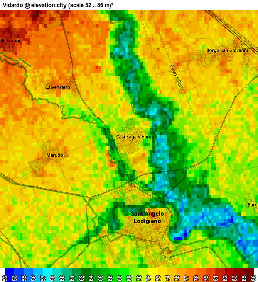
Below is the Elevation map of Vidardo, which displays elevation range with different colors. Scale of the first map is from 52 to 86 m (171 to 282 ft) with average elevation of 71.3 meters (=234 ft) [note 1]
These maps also provides idea of topography and contour of this city, they are displayed at different zoom levels. More info about maps, scale and edge coordinates you can find below images.
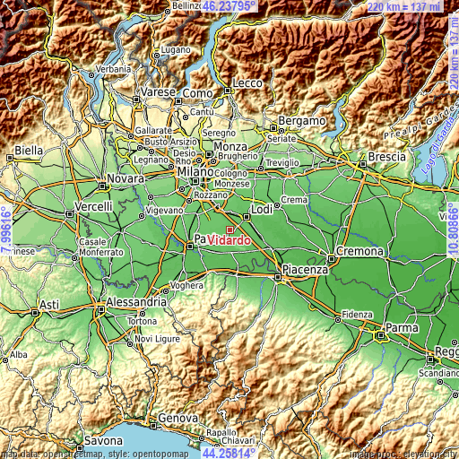
| \ | Map #1 | Topo.Map |
| Scale [m] | 52..86 m | × |
| Scale [ft] | 171..282 ft | × |
| Average | 71.3 m = 234 ft | × |
| Width | 6.88 km = 4.3 mi | 220.1 km = 136.8 mi |
| Height | 6.88 km = 4.3 mi | 220.1 km = 136.8 mi |
| ↑Max Latitude | 45.287596° | 46.23795° |
| Latitude at center | 45.25667° | 45.25667° |
| ↓Min Latitude | 45.225727° | 44.25814° |
| ← Min Longitude | 9.358465° | 7.99616° |
| Longitude center | 9.40241° | 9.40241° |
| →Max Longitude | 9.446355° | 10.80866° |
Nearby cities:
Cities around Vidardo sort by population:
• Sant'Angelo Lodigiano elevation 73 m
2.4 km,  172°
172°
• Lodi Vecchio 78 m
5.4 km,  12°
12°
• Villanterio 70 m
5.4 km,  216°
216°
• Salerano sul Lambro 74 m
4.6 km,  343°
343°
• Caselle Lurani 82 m
4.2 km,  308°
308°
• Borgo San Giovanni 76 m
3.5 km,  47°
47°
• Castiraga Vidardo 73 m
0.2 km,  68°
68°
• Valera Fratta 77 m
5.2 km,  270°
270°
• Marudo 75 m
2 km,  258°
258°
• Pieve Fissiraga 74 m
4.4 km,  80°
80°
• Bargano 71 m
3.9 km,  117°
117°
• Casaletto Lodigiano 84 m
5.2 km,  322°
322°
Multilingual:
 En español:
Vidardo elevación 73 m.
 En France:
Vidardo élévation 73 m.


Sources and notes:
- [note 1] Map square and city borders are not equal. Map elevation data is calculated only from area inside that square.
- [src 1] Elevation data from geonames database provided with same terms of usage.
- [src 2] The elevation map of Vidardo is generated using elevation data from NASA's 3 arcsec (90m) resolution SRTM data.
- [src 3] Base (background) map © OpenStreetMap contributors tiles are generated by Geofabrik and OpenTopoMap.
Copyright & License:
This Vidardo Elevation Map is licensed under CC BY-SA. You may reuse any part from this page, if you give a proper credit by linking to this URL:
 More info on terms of use page.