Miradolo Terme elevation
Miradolo Terme (Lombardy, Provincia di Pavia), Italy elevation is 68 meters and Miradolo Terme elevation in feet is 223 ft above sea level [src 1]. Miradolo Terme is a seat of a third-order administrative division (feature code) with elevation that is 254 meters (833 ft) smaller than average city elevation in Italy.
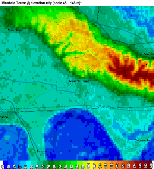
Below is the Elevation map of Miradolo Terme, which displays elevation range with different colors. Scale of the first map is from 45 to 146 m (148 to 479 ft) with average elevation of 73.7 meters (=242 ft) [note 1]
These maps also provides idea of topography and contour of this city, they are displayed at different zoom levels. More info about maps, scale and edge coordinates you can find below images.
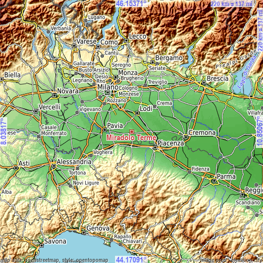
| \ | Map #1 | Topo.Map |
| Scale [m] | 45..146 m | × |
| Scale [ft] | 148..479 ft | × |
| Average | 73.7 m = 242 ft | × |
| Width | 6.89 km = 4.3 mi | 220.5 km = 137 mi |
| Height | 6.89 km = 4.3 mi | 220.5 km = 137 mi |
| ↑Max Latitude | 45.201913° | 46.15371° |
| Latitude at center | 45.17094° | 45.17094° |
| ↓Min Latitude | 45.13995° | 44.17091° |
| ← Min Longitude | 9.400475° | 8.03817° |
| Longitude center | 9.44442° | 9.44442° |
| →Max Longitude | 9.488365° | 10.85067° |
Nearby cities:
Cities around Miradolo Terme sort by population:
• San Colombano al Lambro elevation 70 m
3.8 km,  69°
69°
• Borghetto Lodigiano 68 m
6.4 km,  42°
42°
• Graffignana 69 m
4 km,  11°
11°
• Chignolo Po 67 m
3.9 km,  131°
131°
• Pieve Porto Morone 51 m
6.8 km,  182°
182°
• Corteolona 70 m
5.8 km,  255°
255°
• Santa Cristina 71 m
3.8 km,  246°
246°
• Lambrinia 63 m
6.7 km,  102°
102°
• Inverno e Monteleone 76 m
5.5 km,  302°
302°
• Inverno 77 m
5.6 km, 303°
• Badia Pavese 50 m
5.9 km,  161°
161°
• Costa de' Nobili 64 m
6.7 km,  230°
230°
Multilingual:
 En español:
Miradolo Terme elevación 68 m.
 En France:
Miradolo Terme élévation 68 m.
 Auf Deutsch:
Miradolo Terme höhe über dem Meeresspiegel ist 68 m.

Sources and notes:
- [note 1] Map square and city borders are not equal. Map elevation data is calculated only from area inside that square.
- [src 1] Elevation data from geonames database provided with same terms of usage.
- [src 2] The elevation map of Miradolo Terme is generated using elevation data from NASA's 3 arcsec (90m) resolution SRTM data.
- [src 3] Base (background) map © OpenStreetMap contributors tiles are generated by Geofabrik and OpenTopoMap.
Copyright & License:
This Miradolo Terme Elevation Map is licensed under CC BY-SA. You may reuse any part from this page, if you give a proper credit by linking to this URL:
 More info on terms of use page.