Allein elevation
Allein (Aosta Valley, Valle d'Aosta), Italy elevation is 1215 meters and Allein elevation in feet is 3986 ft above sea level [src 1]. Allein is a seat of a third-order administrative division (feature code) with elevation that is 893 meters (2930 ft) bigger than average city elevation in Italy.
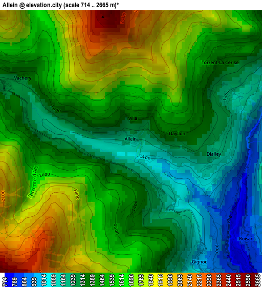
Below is the Elevation map of Allein, which displays elevation range with different colors. Scale of the first map is from 714 to 2665 m (2343 to 8743 ft) with average elevation of 1507.8 meters (=4947 ft) [note 1]
These maps also provides idea of topography and contour of this city, they are displayed at different zoom levels. More info about maps, scale and edge coordinates you can find below images.
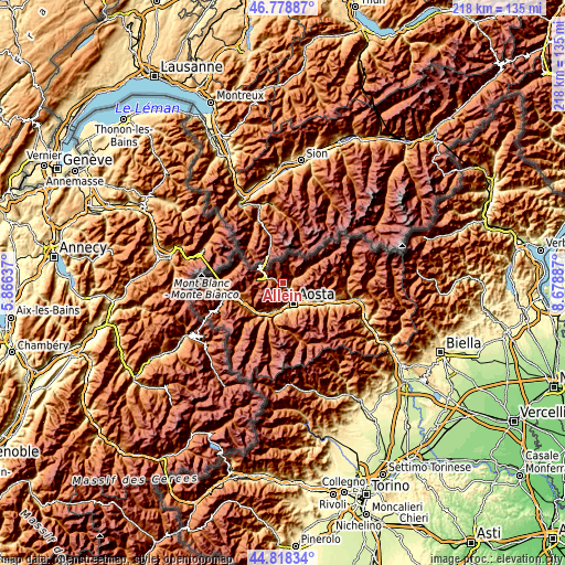
| \ | Map #1 | Topo.Map |
| Scale [m] | 714..2665 m | × |
| Scale [ft] | 2343..8743 ft | × |
| Average | 1507.8 m = 4947 ft | × |
| Width | 6.81 km = 4.2 mi | 218 km = 135.5 mi |
| Height | 6.81 km = 4.2 mi | 218 km = 135.5 mi |
| ↑Max Latitude | 45.837855° | 46.77887° |
| Latitude at center | 45.80723° | 45.80723° |
| ↓Min Latitude | 45.776588° | 44.81834° |
| ← Min Longitude | 7.228675° | 5.86637° |
| Longitude center | 7.27262° | 7.27262° |
| →Max Longitude | 7.316565° | 8.67887° |
Nearby cities:
Cities around Allein sort by population:
• Aosta elevation 585 m
8.5 km,  155°
155°
• Saint-Christophe 774 m
8.3 km,  135°
135°
• La Cretaz-Roisan 873 m
4.1 km,  129°
129°
• Gignod 942 m
3.5 km,  148°
148°
• Valpelline 949 m
4.5 km,  64°
64°
• Etroubles 1278 m
3.5 km,  295°
295°
• Saint-Oyen 1366 m
4.9 km,  292°
292°
• San Leonardo 1534 m
7.3 km,  284°
284°
• Doues 1184 m
2.9 km, 62°
• Ollomont 1375 m
5.6 km,  31°
31°
• Ville Sur Sarre 1207 m
8.3 km,  187°
187°
• Saint-Rhémy 1639 m
7.6 km, 294°
Multilingual:
 En español:
Allein elevación 1215 m.
 En France:
Allein élévation 1215 m.


Sources and notes:
- [note 1] Map square and city borders are not equal. Map elevation data is calculated only from area inside that square.
- [src 1] Elevation data from geonames database provided with same terms of usage.
- [src 2] The elevation map of Allein is generated using elevation data from NASA's 3 arcsec (90m) resolution SRTM data.
- [src 3] Base (background) map © OpenStreetMap contributors tiles are generated by Geofabrik and OpenTopoMap.
Copyright & License:
This Allein Elevation Map is licensed under CC BY-SA. You may reuse any part from this page, if you give a proper credit by linking to this URL:
 More info on terms of use page.