Aosta elevation
Aosta (Aosta Valley, Valle d'Aosta), Italy elevation is 585 meters and Aosta elevation in feet is 1919 ft above sea level [src 1]. Aosta is a seat of a first-order administrative division (feature code) with elevation that is 263 meters (863 ft) bigger than average city elevation in Italy.
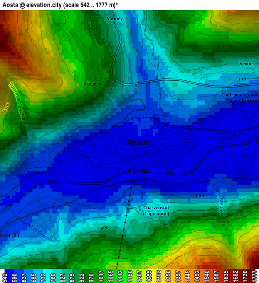
Below is the Elevation map of Aosta, which displays elevation range with different colors. Scale of the first map is from 542 to 1777 m (1778 to 5830 ft) with average elevation of 851.4 meters (=2793 ft) [note 1]
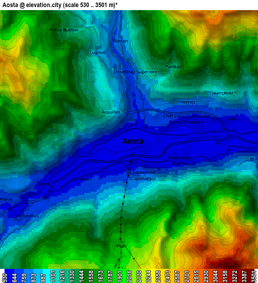
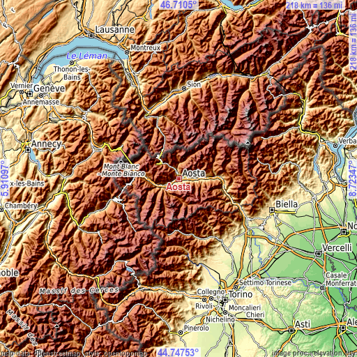
These maps also provides idea of topography and contour of this city, they are displayed at different zoom levels. More info about maps, scale and edge coordinates you can find below images.
| \ | Map #1 | Map #2 | Topo.Map |
| Scale [m] | 542..1777 m | 530..3501 m | × |
| Scale [ft] | 1778..5830 ft | 1739..11486 ft | × |
| Average | 851.4 m = 2793 ft | 1375.7 m = 4513 ft | × |
| Width | 6.82 km = 4.2 mi | 13.64 km = 8.5 mi | 218.3 km = 135.6 mi |
| Height | 6.82 km = 4.2 mi | 13.64 km = 8.5 mi | 218.3 km = 135.6 mi |
| ↑Max Latitude | 45.768303° | 45.798949° | 46.7105° |
| Latitude at center | 45.73764° | 45.73764° | 45.73764° |
| ↓Min Latitude | 45.70696° | 45.676263° | 44.74753° |
| ← Min Longitude | 7.273275° | 7.229329° | 5.91097° |
| Longitude center | 7.31722° | 7.31722° | 7.31722° |
| →Max Longitude | 7.361165° | 7.405111° | 8.72347° |
Nearby cities:
Cities around Aosta sort by population:
• Saint-Christophe elevation 774 m
3 km,  51°
51°
• Gressan 618 m
2.7 km,  224°
224°
• Chef-Lieu 692 m
3.2 km,  62°
62°
• Montan-Angelin-Arensod 614 m
3.3 km,  251°
251°
• Saint Maurice 640 m
5.3 km, 245°
• Villair-Amerique 618 m
5.7 km,  78°
78°
• Pollein 589 m
2.9 km,  112°
112°
• Charvensod 767 m
2 km,  164°
164°
• La Cretaz-Roisan 873 m
5.2 km,  356°
356°
• Jovencan 606 m
4.3 km,  233°
233°
• Gignod 942 m
5 km,  341°
341°
• Ville Sur Sarre 1207 m
4.6 km,  264°
264°
Multilingual:
 En español:
Aosta elevación 585 m.
 En France:
Aoste élévation 585 m.


Sources and notes:
- [note 1] Map square and city borders are not equal. Map elevation data is calculated only from area inside that square.
- [src 1] Elevation data from geonames database provided with same terms of usage.
- [src 2] The elevation map of Aosta is generated using elevation data from NASA's 3 arcsec (90m) resolution SRTM data.
- [src 3] Base (background) map © OpenStreetMap contributors tiles are generated by Geofabrik and OpenTopoMap.
Copyright & License:
This Aosta Elevation Map is licensed under CC BY-SA. You may reuse any part from this page, if you give a proper credit by linking to this URL:
 More info on terms of use page.