Valtopina elevation
Valtopina (Umbria, Provincia di Perugia), Italy elevation is 365 meters and Valtopina elevation in feet is 1198 ft above sea level [src 1]. Valtopina is a seat of a third-order administrative division (feature code) with elevation that is 43 meters (141 ft) bigger than average city elevation in Italy.
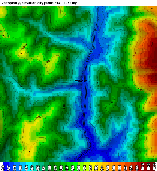
Below is the Elevation map of Valtopina, which displays elevation range with different colors. Scale of the first map is from 318 to 1072 m (1043 to 3517 ft) with average elevation of 573.8 meters (=1883 ft) [note 1]
These maps also provides idea of topography and contour of this city, they are displayed at different zoom levels. More info about maps, scale and edge coordinates you can find below images.
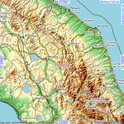
| \ | Map #1 | Topo.Map |
| Scale [m] | 318..1072 m | × |
| Scale [ft] | 1043..3517 ft | × |
| Average | 573.8 m = 1883 ft | × |
| Width | 7.14 km = 4.4 mi | 228.5 km = 142 mi |
| Height | 7.14 km = 4.4 mi | 228.5 km = 142 mi |
| ↑Max Latitude | 43.088841° | 44.07564° |
| Latitude at center | 43.05674° | 43.05674° |
| ↓Min Latitude | 43.024622° | 42.02062° |
| ← Min Longitude | 12.709125° | 11.34682° |
| Longitude center | 12.75307° | 12.75307° |
| →Max Longitude | 12.797015° | 14.15932° |
Nearby cities:
Cities around Valtopina sort by population:
• Foligno elevation 242 m
12 km,  199°
199°
• Bastia umbra 195 m
16.8 km,  272°
272°
• Santa Maria degli Angeli 214 m
14.5 km, 270°
• Spello 213 m
10.1 km,  224°
224°
• Assisi 410 m
10.8 km,  275°
275°
• Cannara 193 m
15.5 km,  243°
243°
• Palazzo 234 m
16 km,  286°
286°
• Nocera Umbra 498 m
7 km,  24°
24°
• Valfabbrica 289 m
16.6 km,  312°
312°
• Rivotorto 226 m
10.8 km,  262°
262°
• Capitan Loreto 212 m
9.6 km, 242°
• Serravalle di Chienti 645 m
16.3 km,  84°
84°
Multilingual:
 En español:
Valtopina elevación 365 m.
 En France:
Valtopina élévation 365 m.
 Auf Deutsch:
Valtopina höhe über dem Meeresspiegel ist 365 m.

Sources and notes:
- [note 1] Map square and city borders are not equal. Map elevation data is calculated only from area inside that square.
- [src 1] Elevation data from geonames database provided with same terms of usage.
- [src 2] The elevation map of Valtopina is generated using elevation data from NASA's 3 arcsec (90m) resolution SRTM data.
- [src 3] Base (background) map © OpenStreetMap contributors tiles are generated by Geofabrik and OpenTopoMap.
Copyright & License:
This Valtopina Elevation Map is licensed under CC BY-SA. You may reuse any part from this page, if you give a proper credit by linking to this URL:
 More info on terms of use page.