Rivotorto elevation
Rivotorto (Umbria, Provincia di Perugia), Italy elevation is 226 meters and Rivotorto elevation in feet is 741 ft above sea level [src 1]. Rivotorto is a populated place (feature code) with elevation that is 96 meters (315 ft) smaller than average city elevation in Italy.
Below is the Elevation map of Rivotorto, which displays elevation range with different colors. Scale of the first map is from 183 to 1171 m (600 to 3842 ft) with average elevation of 339.9 meters (=1115 ft) [note 1]
These maps also provides idea of topography and contour of this city, they are displayed at different zoom levels. More info about maps, scale and edge coordinates you can find below images.
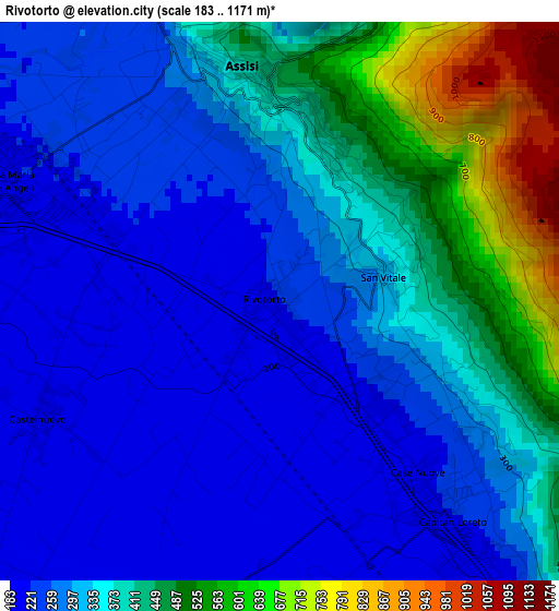
| \ | Map #1 | Topo.Map |
| Scale [m] | 183..1171 m | × |
| Scale [ft] | 600..3842 ft | × |
| Average | 339.9 m = 1115 ft | × |
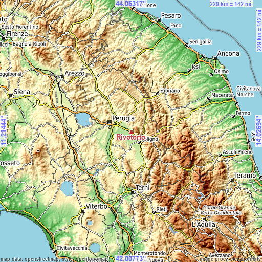
| Width | 7.14 km = 4.4 mi | 228.5 km = 142 mi |
| Height | 7.14 km = 4.4 mi | 228.5 km = 142 mi |
| ↑Max Latitude | 43.076168° | 44.06317° |
| Latitude at center | 43.04406° | 43.04406° |
| ↓Min Latitude | 43.011935° | 42.00773° |
| ← Min Longitude | 12.576745° | 11.21444° |
| Longitude center | 12.62069° | 12.62069° |
| →Max Longitude | 12.664635° | 14.02694° |
Nearby cities:
Cities around Rivotorto sort by population:
• Bastia umbra elevation 195 m
6.5 km,  290°
290°
• Santa Maria degli Angeli 214 m
4 km, 291°
• Spello 213 m
6.8 km,  147°
147°
• Assisi 410 m
2.5 km,  0°
0°
• Petrignano 211 m
9.7 km,  312°
312°
• Cannara 193 m
6.3 km,  210°
210°
• Palazzo 234 m
7.5 km,  322°
322°
• Ospedalicchio 199 m
10.5 km, 291°
• Costano 189 m
7 km,  270°
270°
• Capitan Loreto 212 m
3.7 km,  143°
143°
• Passaggio 188 m
9.5 km,  255°
255°
• Valtopina 365 m
10.8 km,  82°
82°
Multilingual:
 En español:
Rivotorto elevación 226 m.
 En France:
Rivotorto élévation 226 m.
 Auf Deutsch:
Rivotorto höhe über dem Meeresspiegel ist 226 m.

Sources and notes:
- [note 1] Map square and city borders are not equal. Map elevation data is calculated only from area inside that square.
- [src 1] Elevation data from geonames database provided with same terms of usage.
- [src 2] The elevation map of Rivotorto is generated using elevation data from NASA's 3 arcsec (90m) resolution SRTM data.
- [src 3] Base (background) map © OpenStreetMap contributors tiles are generated by Geofabrik and OpenTopoMap.
Copyright & License:
This Rivotorto Elevation Map is licensed under CC BY-SA. You may reuse any part from this page, if you give a proper credit by linking to this URL:
 More info on terms of use page.