Tigliole elevation
Tigliole (Piedmont, Provincia di Asti), Italy elevation is 199 meters and Tigliole elevation in feet is 653 ft above sea level [src 1]. Tigliole is a seat of a third-order administrative division (feature code) with elevation that is 123 meters (404 ft) smaller than average city elevation in Italy.
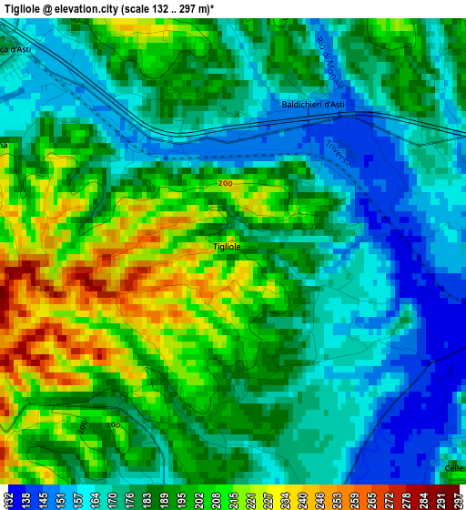
Below is the Elevation map of Tigliole, which displays elevation range with different colors. Scale of the first map is from 132 to 297 m (433 to 974 ft) with average elevation of 185.5 meters (=609 ft) [note 1]
These maps also provides idea of topography and contour of this city, they are displayed at different zoom levels. More info about maps, scale and edge coordinates you can find below images.
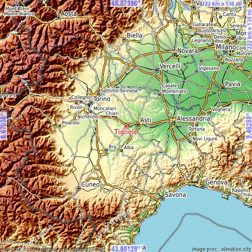
| \ | Map #1 | Topo.Map |
| Scale [m] | 132..297 m | × |
| Scale [ft] | 433..974 ft | × |
| Average | 185.5 m = 609 ft | × |
| Width | 6.92 km = 4.3 mi | 221.6 km = 137.7 mi |
| Height | 6.92 km = 4.3 mi | 221.6 km = 137.7 mi |
| ↑Max Latitude | 44.917377° | 45.87396° |
| Latitude at center | 44.88625° | 44.88625° |
| ↓Min Latitude | 44.855106° | 43.88128° |
| ← Min Longitude | 8.032685° | 6.67038° |
| Longitude center | 8.07663° | 8.07663° |
| →Max Longitude | 8.120575° | 9.48288° |
Nearby cities:
Cities around Tigliole sort by population:
• San Damiano d'Asti elevation 185 m
6 km,  189°
189°
• Villafranca d'Asti 194 m
5.1 km,  309°
309°
• Baldichieri d'Asti 150 m
2.5 km,  28°
28°
• Ferrere 237 m
6.6 km,  260°
260°
• Revigliasco d'Asti 192 m
7.3 km,  115°
115°
• Antignano 257 m
6.5 km,  134°
134°
• Celle Enomondo 223 m
4.9 km, 131°
• San Martino Alfieri 253 m
8 km,  160°
160°
• Cantarana 163 m
4.3 km,  294°
294°
• Monale 168 m
5.7 km,  356°
356°
• Castellero 239 m
4.4 km, 357°
• Maretto 247 m
7.3 km,  332°
332°
Multilingual:
 En español:
Tigliole elevación 199 m.
 En France:
Tigliole élévation 199 m.
 Auf Deutsch:
Tigliole höhe über dem Meeresspiegel ist 199 m.

Sources and notes:
- [note 1] Map square and city borders are not equal. Map elevation data is calculated only from area inside that square.
- [src 1] Elevation data from geonames database provided with same terms of usage.
- [src 2] The elevation map of Tigliole is generated using elevation data from NASA's 3 arcsec (90m) resolution SRTM data.
- [src 3] Base (background) map © OpenStreetMap contributors tiles are generated by Geofabrik and OpenTopoMap.
Copyright & License:
This Tigliole Elevation Map is licensed under CC BY-SA. You may reuse any part from this page, if you give a proper credit by linking to this URL:
 More info on terms of use page.