Castellero elevation
Castellero (Piedmont, Provincia di Asti), Italy elevation is 239 meters and Castellero elevation in feet is 784 ft above sea level [src 1]. Castellero is a seat of a third-order administrative division (feature code) with elevation that is 83 meters (272 ft) smaller than average city elevation in Italy.
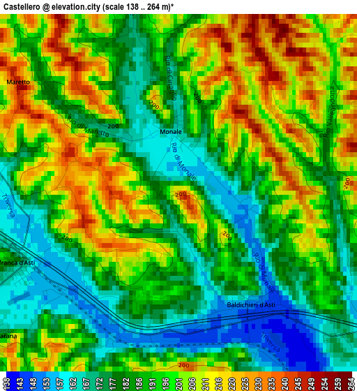
Below is the Elevation map of Castellero, which displays elevation range with different colors. Scale of the first map is from 138 to 264 m (453 to 866 ft) with average elevation of 192 meters (=630 ft) [note 1]
These maps also provides idea of topography and contour of this city, they are displayed at different zoom levels. More info about maps, scale and edge coordinates you can find below images.
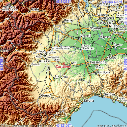
| \ | Map #1 | Topo.Map |
| Scale [m] | 138..264 m | × |
| Scale [ft] | 453..866 ft | × |
| Average | 192 m = 630 ft | × |
| Width | 6.92 km = 4.3 mi | 221.4 km = 137.6 mi |
| Height | 6.92 km = 4.3 mi | 221.4 km = 137.6 mi |
| ↑Max Latitude | 44.956456° | 45.91239° |
| Latitude at center | 44.92535° | 44.92535° |
| ↓Min Latitude | 44.894227° | 43.92106° |
| ← Min Longitude | 8.029885° | 6.66758° |
| Longitude center | 8.07383° | 8.07383° |
| →Max Longitude | 8.117775° | 9.48008° |
Nearby cities:
Cities around Castellero sort by population:
• Villafranca d'Asti elevation 194 m
3.9 km,  253°
253°
• Baldichieri d'Asti 150 m
2.6 km,  146°
146°
• Settime 253 m
5.2 km,  38°
38°
• Camerano 295 m
7.4 km,  9°
9°
• Cinaglio 254 m
5.9 km,  20°
20°
• Cantarana 163 m
4.4 km,  235°
235°
• Monale 168 m
1.4 km,  355°
355°
• Tigliole 199 m
4.4 km,  177°
177°
• Cortazzone 201 m
6.1 km,  350°
350°
• Cortandone 210 m
3.9 km,  342°
342°
• Roatto 257 m
4.7 km,  308°
308°
• Maretto 247 m
3.8 km,  304°
304°
Multilingual:
 En español:
Castellero elevación 239 m.
 En France:
Castellero élévation 239 m.
 Auf Deutsch:
Castellero höhe über dem Meeresspiegel ist 239 m.

Sources and notes:
- [note 1] Map square and city borders are not equal. Map elevation data is calculated only from area inside that square.
- [src 1] Elevation data from geonames database provided with same terms of usage.
- [src 2] The elevation map of Castellero is generated using elevation data from NASA's 3 arcsec (90m) resolution SRTM data.
- [src 3] Base (background) map © OpenStreetMap contributors tiles are generated by Geofabrik and OpenTopoMap.
Copyright & License:
This Castellero Elevation Map is licensed under CC BY-SA. You may reuse any part from this page, if you give a proper credit by linking to this URL:
 More info on terms of use page.