Antignano elevation
Antignano (Piedmont, Provincia di Asti), Italy elevation is 257 meters and Antignano elevation in feet is 843 ft above sea level [src 1]. Antignano is a seat of a third-order administrative division (feature code) with elevation that is 65 meters (213 ft) smaller than average city elevation in Italy.
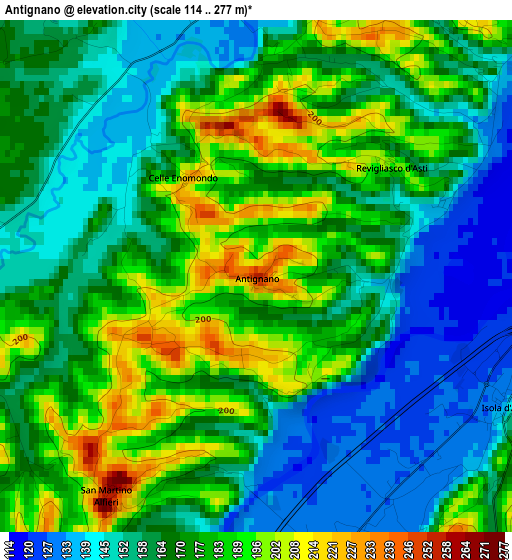
Below is the Elevation map of Antignano, which displays elevation range with different colors. Scale of the first map is from 114 to 277 m (374 to 909 ft) with average elevation of 168.7 meters (=553 ft) [note 1]
These maps also provides idea of topography and contour of this city, they are displayed at different zoom levels. More info about maps, scale and edge coordinates you can find below images.
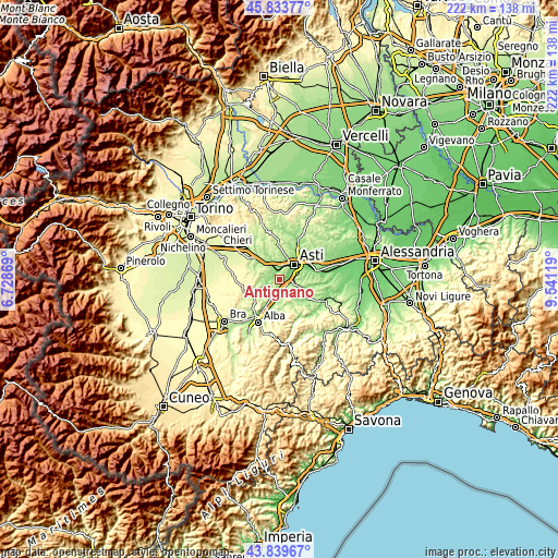
| \ | Map #1 | Topo.Map |
| Scale [m] | 114..277 m | × |
| Scale [ft] | 374..909 ft | × |
| Average | 168.7 m = 553 ft | × |
| Width | 6.93 km = 4.3 mi | 221.7 km = 137.8 mi |
| Height | 6.93 km = 4.3 mi | 221.7 km = 137.8 mi |
| ↑Max Latitude | 44.876499° | 45.83377° |
| Latitude at center | 44.84535° | 44.84535° |
| ↓Min Latitude | 44.814184° | 43.83967° |
| ← Min Longitude | 8.090995° | 6.72869° |
| Longitude center | 8.13494° | 8.13494° |
| →Max Longitude | 8.178885° | 9.54119° |
Nearby cities:
Cities around Antignano sort by population:
• San Damiano d'Asti elevation 185 m
5.8 km,  256°
256°
• Isola d'Asti 126 m
3.8 km,  110°
110°
• Costigliole d'Asti 238 m
7.7 km,  149°
149°
• Piano-Molini d'Isola 144 m
3.9 km, 112°
• Baldichieri d'Asti 150 m
7.6 km,  333°
333°
• Govone 238 m
5.6 km,  215°
215°
• Revigliasco d'Asti 192 m
2.4 km,  55°
55°
• Mongardino 284 m
6.6 km,  86°
86°
• Celle Enomondo 223 m
1.6 km, 325°
• San Martino Alfieri 253 m
3.6 km,  212°
212°
• Vigliano d'Asti 245 m
7.5 km,  99°
99°
• Tigliole 199 m
6.5 km,  314°
314°
Multilingual:
 En español:
Antignano elevación 257 m.
 En France:
Antignano élévation 257 m.
 Auf Deutsch:
Antignano höhe über dem Meeresspiegel ist 257 m.

Sources and notes:
- [note 1] Map square and city borders are not equal. Map elevation data is calculated only from area inside that square.
- [src 1] Elevation data from geonames database provided with same terms of usage.
- [src 2] The elevation map of Antignano is generated using elevation data from NASA's 3 arcsec (90m) resolution SRTM data.
- [src 3] Base (background) map © OpenStreetMap contributors tiles are generated by Geofabrik and OpenTopoMap.
Copyright & License:
This Antignano Elevation Map is licensed under CC BY-SA. You may reuse any part from this page, if you give a proper credit by linking to this URL:
 More info on terms of use page.