Larciano elevation
Larciano (Tuscany, Provincia di Pistoia), Italy elevation is 155 meters and Larciano elevation in feet is 509 ft above sea level [src 1]. Larciano is a seat of a third-order administrative division (feature code) with elevation that is 167 meters (548 ft) smaller than average city elevation in Italy.
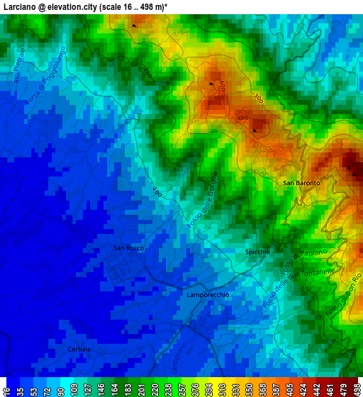
Below is the Elevation map of Larciano, which displays elevation range with different colors. Scale of the first map is from 16 to 498 m (52 to 1634 ft) with average elevation of 139 meters (=456 ft) [note 1]
These maps also provides idea of topography and contour of this city, they are displayed at different zoom levels. More info about maps, scale and edge coordinates you can find below images.
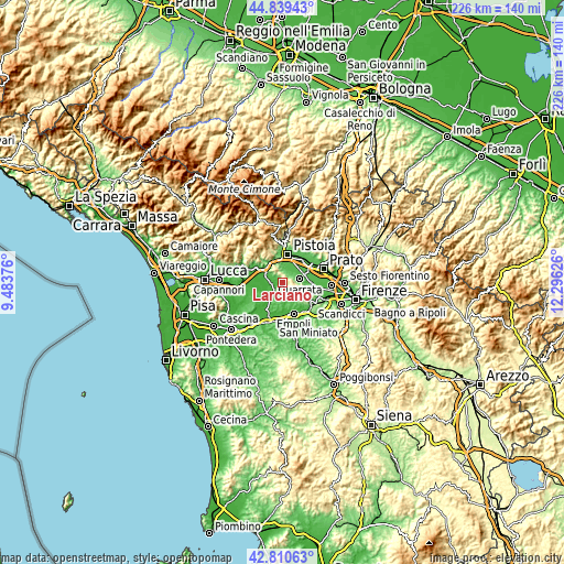
| \ | Map #1 | Topo.Map |
| Scale [m] | 16..498 m | × |
| Scale [ft] | 52..1634 ft | × |
| Average | 139 m = 456 ft | × |
| Width | 7.05 km = 4.4 mi | 225.6 km = 140.2 mi |
| Height | 7.05 km = 4.4 mi | 225.6 km = 140.2 mi |
| ↑Max Latitude | 43.865342° | 44.83943° |
| Latitude at center | 43.83365° | 43.83365° |
| ↓Min Latitude | 43.801941° | 42.81063° |
| ← Min Longitude | 10.846065° | 9.48376° |
| Longitude center | 10.89001° | 10.89001° |
| →Max Longitude | 10.933955° | 12.29626° |
Nearby cities:
Cities around Larciano sort by population:
• Monsummano Terme elevation 23 m
7.2 km,  301°
301°
• Quarrata 48 m
7.3 km,  77°
77°
• Cantagrillo-Casalguidi 76 m
4.4 km,  25°
25°
• Lamporecchio 35 m
3.1 km,  199°
199°
• San Rocco 25 m
2.6 km,  243°
243°
• Cintolese 24 m
5.3 km,  285°
285°
• Cerreto Guidi 109 m
8.4 km,  184°
184°
• Valenzatico 41 m
7.1 km,  58°
58°
• Stabbia 21 m
7.2 km,  218°
218°
• Vinci 66 m
6.4 km,  155°
155°
• Uggia-Pazzera-Bizzarrino 21 m
4.7 km,  270°
270°
• Lazzeretto 40 m
6.1 km, 202°
Multilingual:
 En español:
Larciano elevación 155 m.
 En France:
Larciano élévation 155 m.
 Auf Deutsch:
Larciano höhe über dem Meeresspiegel ist 155 m.

Sources and notes:
- [note 1] Map square and city borders are not equal. Map elevation data is calculated only from area inside that square.
- [src 1] Elevation data from geonames database provided with same terms of usage.
- [src 2] The elevation map of Larciano is generated using elevation data from NASA's 3 arcsec (90m) resolution SRTM data.
- [src 3] Base (background) map © OpenStreetMap contributors tiles are generated by Geofabrik and OpenTopoMap.
Copyright & License:
This Larciano Elevation Map is licensed under CC BY-SA. You may reuse any part from this page, if you give a proper credit by linking to this URL:
 More info on terms of use page.