Cintolese elevation
Cintolese (Tuscany, Provincia di Pistoia), Italy elevation is 24 meters and Cintolese elevation in feet is 79 ft above sea level [src 1]. Cintolese is a populated place (feature code) with elevation that is 298 meters (978 ft) smaller than average city elevation in Italy.
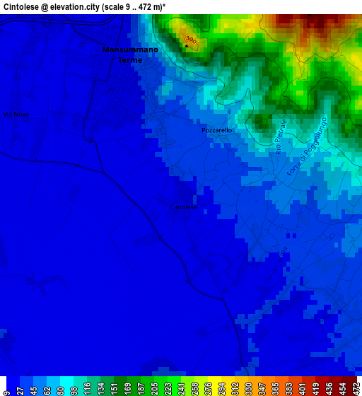
Below is the Elevation map of Cintolese, which displays elevation range with different colors. Scale of the first map is from 9 to 472 m (30 to 1549 ft) with average elevation of 54 meters (=177 ft) [note 1]
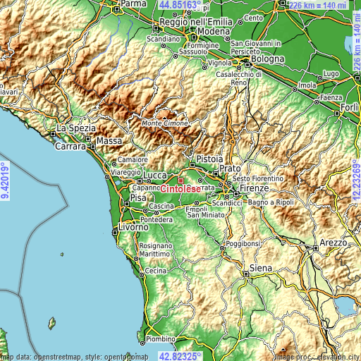
These maps also provides idea of topography and contour of this city, they are displayed at different zoom levels. More info about maps, scale and edge coordinates you can find below images.
| \ | Map #1 | Topo.Map |
| Scale [m] | 9..472 m | × |
| Scale [ft] | 30..1549 ft | × |
| Average | 54 m = 177 ft | × |
| Width | 7.05 km = 4.4 mi | 225.5 km = 140.1 mi |
| Height | 7.05 km = 4.4 mi | 225.5 km = 140.1 mi |
| ↑Max Latitude | 43.877745° | 44.85163° |
| Latitude at center | 43.84606° | 43.84606° |
| ↓Min Latitude | 43.814358° | 42.82325° |
| ← Min Longitude | 10.782495° | 9.42019° |
| Longitude center | 10.82644° | 10.82644° |
| →Max Longitude | 10.870385° | 12.23269° |
Nearby cities:
Cities around Cintolese sort by population:
• Montecatini-Terme elevation 30 m
5.9 km,  312°
312°
• Monsummano Terme 23 m
2.6 km,  335°
335°
• Pieve a Nievole 28 m
4.4 km,  331°
331°
• Margine Coperta-Traversagna 22 m
6.7 km,  304°
304°
• Lamporecchio 35 m
5.9 km,  136°
136°
• Ponte Buggianese 17 m
6.3 km,  269°
269°
• San Rocco 25 m
3.8 km,  132°
132°
• Stabbia 21 m
7.1 km,  174°
174°
• Uggia-Pazzera-Bizzarrino 21 m
1.4 km,  162°
162°
• Anchione 18 m
5.9 km,  247°
247°
• Serravalle Pistoiese 176 m
6.7 km,  4°
4°
• Larciano 155 m
5.3 km,  105°
105°
Multilingual:
 En español:
Cintolese elevación 24 m.
 En France:
Cintolese élévation 24 m.
 Auf Deutsch:
Cintolese höhe über dem Meeresspiegel ist 24 m.

Sources and notes:
- [note 1] Map square and city borders are not equal. Map elevation data is calculated only from area inside that square.
- [src 1] Elevation data from geonames database provided with same terms of usage.
- [src 2] The elevation map of Cintolese is generated using elevation data from NASA's 3 arcsec (90m) resolution SRTM data.
- [src 3] Base (background) map © OpenStreetMap contributors tiles are generated by Geofabrik and OpenTopoMap.
Copyright & License:
This Cintolese Elevation Map is licensed under CC BY-SA. You may reuse any part from this page, if you give a proper credit by linking to this URL:
 More info on terms of use page.