Pedemonte elevation
Pedemonte (Veneto, Provincia di Vicenza), Italy elevation is 443 meters and Pedemonte elevation in feet is 1453 ft above sea level [src 1]. Pedemonte is a seat of a third-order administrative division (feature code) with elevation that is 121 meters (397 ft) bigger than average city elevation in Italy.
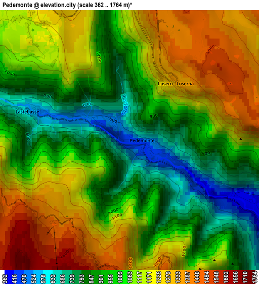
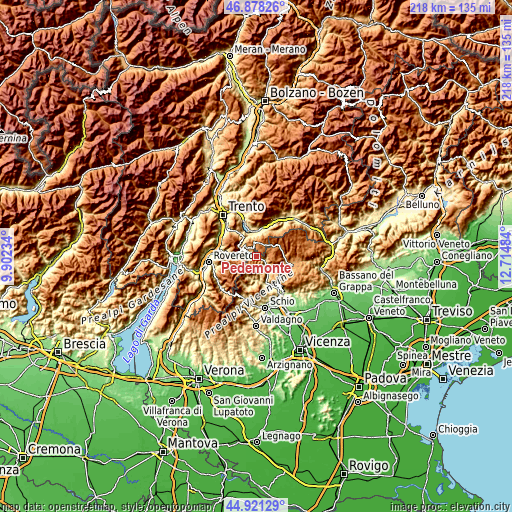
Below is the Elevation map of Pedemonte, which displays elevation range with different colors. Scale of the first map is from 362 to 1764 m (1188 to 5787 ft) with average elevation of 1056.1 meters (=3465 ft) [note 1]
These maps also provides idea of topography and contour of this city, they are displayed at different zoom levels. More info about maps, scale and edge coordinates you can find below images.
| \ | Map #1 | Topo.Map |
| Scale [m] | 362..1764 m | × |
| Scale [ft] | 1188..5787 ft | × |
| Average | 1056.1 m = 3465 ft | × |
| Width | 6.8 km = 4.2 mi | 217.6 km = 135.2 mi |
| Height | 6.8 km = 4.2 mi | 217.6 km = 135.2 mi |
| ↑Max Latitude | 45.938969° | 46.87826° |
| Latitude at center | 45.9084° | 45.9084° |
| ↓Min Latitude | 45.877814° | 44.92129° |
| ← Min Longitude | 11.264645° | 9.90234° |
| Longitude center | 11.30859° | 11.30859° |
| →Max Longitude | 11.352535° | 12.71484° |
Nearby cities:
Cities around Pedemonte sort by population:
• Levico Terme elevation 523 m
11.5 km,  358°
358°
• Caldonazzo 477 m
10.1 km,  340°
340°
• Folgaria 1151 m
10.9 km,  274°
274°
• Rotzo 920 m
8.5 km,  127°
127°
• San Pietro Valdastico 396 m
4.8 km,  120°
120°
• Gionghi-Cappella 1169 m
4.1 km,  320°
320°
• Luserna 1334 m
1.9 km,  35°
35°
• Longhi 442 m
0.2 km, 116°
• Centa San Nicolò 834 m
9 km, 318°
• Tonezza del Cimone 973 m
6.2 km,  152°
152°
• Lastebasse 568 m
2.8 km,  285°
285°
• Laghi 564 m
9.7 km,  196°
196°
Multilingual:
 En español:
Pedemonte elevación 443 m.
 En France:
Pedemonte élévation 443 m.
 Auf Deutsch:
Pedemonte höhe über dem Meeresspiegel ist 443 m.

Sources and notes:
- [note 1] Map square and city borders are not equal. Map elevation data is calculated only from area inside that square.
- [src 1] Elevation data from geonames database provided with same terms of usage.
- [src 2] The elevation map of Pedemonte is generated using elevation data from NASA's 3 arcsec (90m) resolution SRTM data.
- [src 3] Base (background) map © OpenStreetMap contributors tiles are generated by Geofabrik and OpenTopoMap.
Copyright & License:
This Pedemonte Elevation Map is licensed under CC BY-SA. You may reuse any part from this page, if you give a proper credit by linking to this URL:
 More info on terms of use page.