Levico Terme elevation
Levico Terme (Trentino-Alto Adige, Provincia autonoma di Trento), Italy elevation is 523 meters and Levico Terme elevation in feet is 1716 ft above sea level [src 1]. Levico Terme is a seat of a third-order administrative division (feature code) with elevation that is 201 meters (659 ft) bigger than average city elevation in Italy.
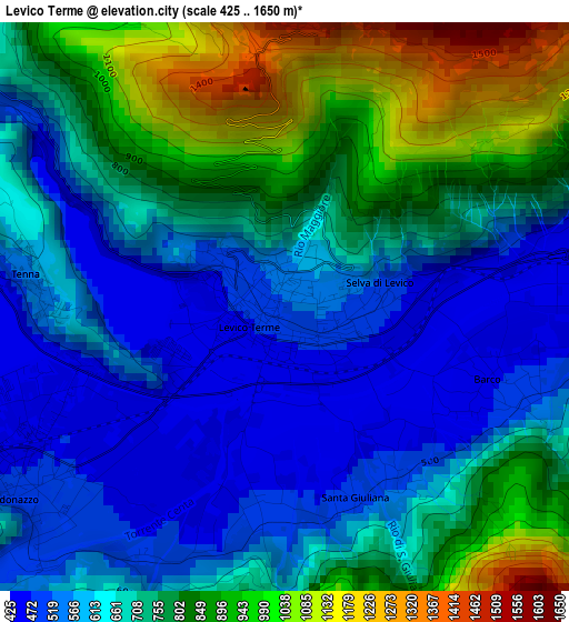
Below is the Elevation map of Levico Terme, which displays elevation range with different colors. Scale of the first map is from 425 to 1650 m (1394 to 5413 ft) with average elevation of 710.2 meters (=2330 ft) [note 1]
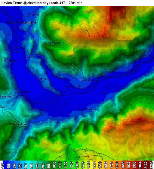
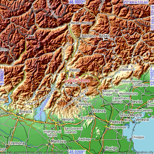
These maps also provides idea of topography and contour of this city, they are displayed at different zoom levels. More info about maps, scale and edge coordinates you can find below images.
| \ | Map #1 | Map #2 | Topo.Map |
| Scale [m] | 425..1650 m | 417..2201 m | × |
| Scale [ft] | 1394..5413 ft | 1368..7221 ft | × |
| Average | 710.2 m = 2330 ft | 981.3 m = 3219 ft | × |
| Width | 6.79 km = 4.2 mi | 13.57 km = 8.4 mi | 217.2 km = 135 mi |
| Height | 6.79 km = 4.2 mi | 13.57 km = 8.4 mi | 217.2 km = 135 mi |
| ↑Max Latitude | 46.042682° | 46.073177° | 46.9802° |
| Latitude at center | 46.01217° | 46.01217° | 46.01217° |
| ↓Min Latitude | 45.981641° | 45.951096° | 45.0269° |
| ← Min Longitude | 11.260325° | 11.216379° | 9.89802° |
| Longitude center | 11.30427° | 11.30427° | 11.30427° |
| →Max Longitude | 11.348215° | 11.392161° | 12.71052° |
Nearby cities:
Cities around Levico Terme sort by population:
• Pergine Valsugana elevation 477 m
7.8 km,  318°
318°
• Caldonazzo 477 m
3.7 km,  236°
236°
• Vigolo Vattaro 725 m
8.3 km,  264°
264°
• Calceranica al Lago 459 m
4.8 km, 259°
• Vattaro 694 m
7 km,  253°
253°
• Tenna 554 m
3.1 km,  277°
277°
• Bosentino-Migazzone 681 m
6.4 km, 259°
• Novaledo 486 m
4.9 km,  75°
75°
• Gionghi-Cappella 1169 m
8.7 km,  195°
195°
• Centa San Nicolò 834 m
7.3 km,  229°
229°
• Frassilongo 849 m
8.7 km,  356°
356°
• Vignola 994 m
4.1 km,  329°
329°
Multilingual:
 En español:
Levico Terme elevación 523 m.
 En France:
Levico Terme élévation 523 m.
 Auf Deutsch:
Levico Terme höhe über dem Meeresspiegel ist 523 m.

Sources and notes:
- [note 1] Map square and city borders are not equal. Map elevation data is calculated only from area inside that square.
- [src 1] Elevation data from geonames database provided with same terms of usage.
- [src 2] The elevation map of Levico Terme is generated using elevation data from NASA's 3 arcsec (90m) resolution SRTM data.
- [src 3] Base (background) map © OpenStreetMap contributors tiles are generated by Geofabrik and OpenTopoMap.
Copyright & License:
This Levico Terme Elevation Map is licensed under CC BY-SA. You may reuse any part from this page, if you give a proper credit by linking to this URL:
 More info on terms of use page.