Rotzo elevation
Rotzo (Veneto, Provincia di Vicenza), Italy elevation is 920 meters and Rotzo elevation in feet is 3018 ft above sea level [src 1]. Rotzo is a seat of a third-order administrative division (feature code) with elevation that is 598 meters (1962 ft) bigger than average city elevation in Italy.
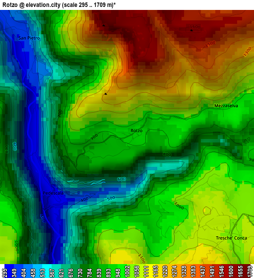
Below is the Elevation map of Rotzo, which displays elevation range with different colors. Scale of the first map is from 295 to 1709 m (968 to 5607 ft) with average elevation of 930.6 meters (=3053 ft) [note 1]
These maps also provides idea of topography and contour of this city, they are displayed at different zoom levels. More info about maps, scale and edge coordinates you can find below images.
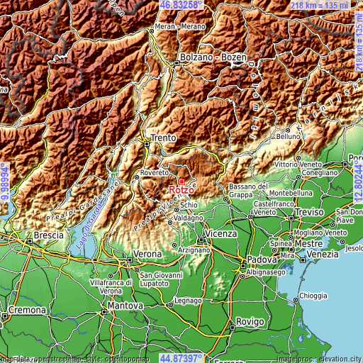
| \ | Map #1 | Topo.Map |
| Scale [m] | 295..1709 m | × |
| Scale [ft] | 968..5607 ft | × |
| Average | 930.6 m = 3053 ft | × |
| Width | 6.81 km = 4.2 mi | 217.8 km = 135.3 mi |
| Height | 6.81 km = 4.2 mi | 217.8 km = 135.3 mi |
| ↑Max Latitude | 45.892495° | 46.83258° |
| Latitude at center | 45.8619° | 45.8619° |
| ↓Min Latitude | 45.831288° | 44.87397° |
| ← Min Longitude | 11.352245° | 9.98994° |
| Longitude center | 11.39619° | 11.39619° |
| →Max Longitude | 11.440135° | 12.80244° |
Nearby cities:
Cities around Rotzo sort by population:
• Asiago elevation 1000 m
9.1 km,  80°
80°
• Cogollo del Cengio 299 m
9 km,  165°
165°
• Arsiero 314 m
7.1 km,  205°
205°
• Velo d'Astico 347 m
8.5 km,  195°
195°
• Canove di Roana 990 m
6 km,  88°
88°
• Roana 1021 m
4.7 km,  69°
69°
• Pedemonte 443 m
8.5 km,  307°
307°
• Velo 327 m
8.3 km, 195°
• San Pietro Valdastico 396 m
3.8 km,  315°
315°
• Luserna 1334 m
8.8 km, 319°
• Longhi 442 m
8.3 km, 307°
• Tonezza del Cimone 973 m
3.9 km,  265°
265°
Multilingual:
 En español:
Rotzo elevación 920 m.
 En France:
Rotzo élévation 920 m.


Sources and notes:
- [note 1] Map square and city borders are not equal. Map elevation data is calculated only from area inside that square.
- [src 1] Elevation data from geonames database provided with same terms of usage.
- [src 2] The elevation map of Rotzo is generated using elevation data from NASA's 3 arcsec (90m) resolution SRTM data.
- [src 3] Base (background) map © OpenStreetMap contributors tiles are generated by Geofabrik and OpenTopoMap.
Copyright & License:
This Rotzo Elevation Map is licensed under CC BY-SA. You may reuse any part from this page, if you give a proper credit by linking to this URL:
 More info on terms of use page.