Pradamano elevation
Pradamano (Friuli Venezia Giulia, Provincia di Udine), Italy elevation is 88 meters and Pradamano elevation in feet is 289 ft above sea level [src 1]. Pradamano is a seat of a third-order administrative division (feature code) with elevation that is 234 meters (768 ft) smaller than average city elevation in Italy.
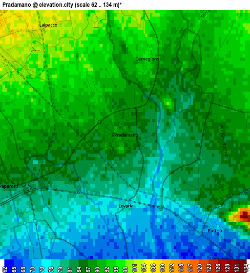
Below is the Elevation map of Pradamano, which displays elevation range with different colors. Scale of the first map is from 62 to 134 m (203 to 440 ft) with average elevation of 85.5 meters (=281 ft) [note 1]
These maps also provides idea of topography and contour of this city, they are displayed at different zoom levels. More info about maps, scale and edge coordinates you can find below images.
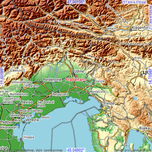
| \ | Map #1 | Topo.Map |
| Scale [m] | 62..134 m | × |
| Scale [ft] | 203..440 ft | × |
| Average | 85.5 m = 281 ft | × |
| Width | 6.78 km = 4.2 mi | 217.1 km = 134.9 mi |
| Height | 6.78 km = 4.2 mi | 217.1 km = 134.9 mi |
| ↑Max Latitude | 46.06441° | 47.00156° |
| Latitude at center | 46.03391° | 46.03391° |
| ↓Min Latitude | 46.003393° | 45.04902° |
| ← Min Longitude | 13.258285° | 11.89598° |
| Longitude center | 13.30223° | 13.30223° |
| →Max Longitude | 13.346175° | 14.70848° |
Nearby cities:
Cities around Pradamano sort by population:
• Udine elevation 116 m
6.4 km,  308°
308°
• Manzano 66 m
7.7 km,  131°
131°
• Buttrio 73 m
3.5 km,  136°
136°
• Basaldella 83 m
6.6 km,  261°
261°
• Zugliano-Terenzano-Cargnacco 74 m
7.2 km,  245°
245°
• Remanzacco 110 m
6 km,  16°
16°
• Premariacco 113 m
7.8 km,  66°
66°
• Percoto 58 m
6.8 km,  166°
166°
• Moimacco 115 m
8.4 km,  40°
40°
• Lauzacco 60 m
6.1 km,  196°
196°
• Pavia di Udine 65 m
4.3 km,  178°
178°
• Orsaria 98 m
6.2 km,  85°
85°
Multilingual:
 En español:
Pradamano elevación 88 m.
 En France:
Pradamano élévation 88 m.
 Auf Deutsch:
Pradamano höhe über dem Meeresspiegel ist 88 m.

Sources and notes:
- [note 1] Map square and city borders are not equal. Map elevation data is calculated only from area inside that square.
- [src 1] Elevation data from geonames database provided with same terms of usage.
- [src 2] The elevation map of Pradamano is generated using elevation data from NASA's 3 arcsec (90m) resolution SRTM data.
- [src 3] Base (background) map © OpenStreetMap contributors tiles are generated by Geofabrik and OpenTopoMap.
Copyright & License:
This Pradamano Elevation Map is licensed under CC BY-SA. You may reuse any part from this page, if you give a proper credit by linking to this URL:
 More info on terms of use page.