Premariacco elevation
Premariacco (Friuli Venezia Giulia, Provincia di Udine), Italy elevation is 113 meters and Premariacco elevation in feet is 371 ft above sea level [src 1]. Premariacco is a seat of a third-order administrative division (feature code) with elevation that is 209 meters (686 ft) smaller than average city elevation in Italy.
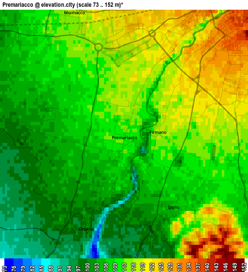
Below is the Elevation map of Premariacco, which displays elevation range with different colors. Scale of the first map is from 73 to 152 m (240 to 499 ft) with average elevation of 110.4 meters (=362 ft) [note 1]
These maps also provides idea of topography and contour of this city, they are displayed at different zoom levels. More info about maps, scale and edge coordinates you can find below images.
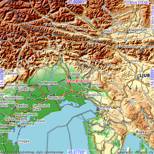
| \ | Map #1 | Topo.Map |
| Scale [m] | 73..152 m | × |
| Scale [ft] | 240..499 ft | × |
| Average | 110.4 m = 362 ft | × |
| Width | 6.78 km = 4.2 mi | 217 km = 134.8 mi |
| Height | 6.78 km = 4.2 mi | 217 km = 134.8 mi |
| ↑Max Latitude | 46.091935° | 47.02861° |
| Latitude at center | 46.06145° | 46.06145° |
| ↓Min Latitude | 46.030949° | 45.07705° |
| ← Min Longitude | 13.350665° | 11.98836° |
| Longitude center | 13.39461° | 13.39461° |
| →Max Longitude | 13.438555° | 14.80086° |
Nearby cities:
Cities around Premariacco sort by population:
• Cividale del Friuli elevation 122 m
4.1 km,  39°
39°
• Manzano 66 m
8.2 km,  189°
189°
• Buttrio 73 m
7.3 km,  220°
220°
• Remanzacco 110 m
6.1 km,  295°
295°
• Pradamano 88 m
7.8 km,  246°
246°
• Corno di Rosazzo 82 m
8.7 km,  154°
154°
• San Pietro al Natisone 158 m
9 km,  49°
49°
• Moimacco 115 m
3.7 km,  333°
333°
• Orsaria 98 m
2.7 km,  200°
200°
• Torreano 174 m
7.9 km,  19°
19°
• Prepotto 105 m
6.8 km,  105°
105°
• Dolegna del Collio 88 m
7.3 km,  117°
117°
Multilingual:
 En español:
Premariacco elevación 113 m.
 En France:
Premariacco élévation 113 m.
 Auf Deutsch:
Premariacco höhe über dem Meeresspiegel ist 113 m.

Sources and notes:
- [note 1] Map square and city borders are not equal. Map elevation data is calculated only from area inside that square.
- [src 1] Elevation data from geonames database provided with same terms of usage.
- [src 2] The elevation map of Premariacco is generated using elevation data from NASA's 3 arcsec (90m) resolution SRTM data.
- [src 3] Base (background) map © OpenStreetMap contributors tiles are generated by Geofabrik and OpenTopoMap.
Copyright & License:
This Premariacco Elevation Map is licensed under CC BY-SA. You may reuse any part from this page, if you give a proper credit by linking to this URL:
 More info on terms of use page.