Udine elevation
Udine (Friuli Venezia Giulia, Provincia di Udine), Italy elevation is 116 meters and Udine elevation in feet is 381 ft above sea level [src 1]. Udine is a seat of a second-order administrative division (feature code) with elevation that is 206 meters (676 ft) smaller than average city elevation in Italy.
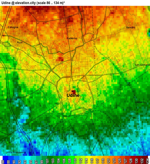
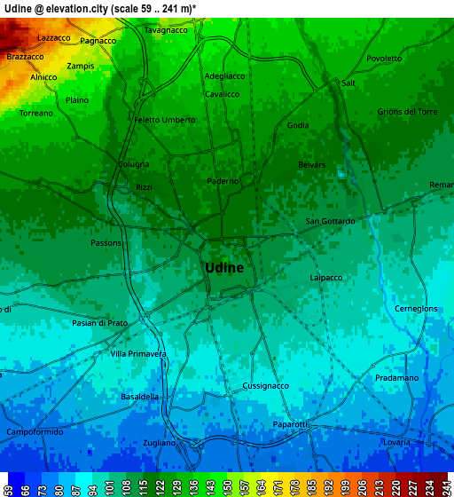
Below is the Elevation map of Udine, which displays elevation range with different colors. Scale of the first map is from 86 to 134 m (282 to 440 ft) with average elevation of 110.2 meters (=362 ft) [note 1]
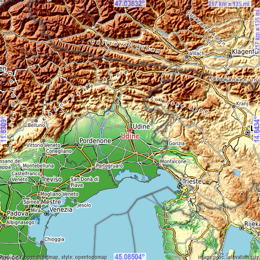
These maps also provides idea of topography and contour of this city, they are displayed at different zoom levels. More info about maps, scale and edge coordinates you can find below images.
| \ | Map #1 | Map #2 | Topo.Map |
| Scale [m] | 86..134 m | 59..241 m | × |
| Scale [ft] | 282..440 ft | 194..791 ft | × |
| Average | 110.2 m = 362 ft | 109.2 m = 358 ft | × |
| Width | 6.78 km = 4.2 mi | 13.56 km = 8.4 mi | 217 km = 134.8 mi |
| Height | 6.78 km = 4.2 mi | 13.56 km = 8.4 mi | 217 km = 134.8 mi |
| ↑Max Latitude | 46.09978° | 46.130244° | 47.03632° |
| Latitude at center | 46.0693° | 46.0693° | 46.0693° |
| ↓Min Latitude | 46.038803° | 46.008289° | 45.08504° |
| ← Min Longitude | 13.193205° | 13.149259° | 11.8309° |
| Longitude center | 13.23715° | 13.23715° | 13.23715° |
| →Max Longitude | 13.281095° | 13.325041° | 14.6434° |
Nearby cities:
Cities around Udine sort by population:
• Tavagnacco elevation 134 m
4.6 km,  345°
345°
• Pasian di Prato 99 m
4.6 km,  236°
236°
• Pagnacco 150 m
6.5 km,  320°
320°
• Basaldella 83 m
5.1 km,  197°
197°
• Zugliano-Terenzano-Cargnacco 74 m
7 km,  192°
192°
• Remanzacco 110 m
6.9 km,  75°
75°
• Pradamano 88 m
6.4 km,  128°
128°
• Passons 114 m
3.7 km,  269°
269°
• Colugna 122 m
3.6 km,  312°
312°
• Povoletto 129 m
6.7 km,  39°
39°
• Colloredo di Prato 96 m
7.5 km,  254°
254°
• Feletto Umberto 126 m
3.9 km,  342°
342°
Multilingual:
 En español:
Udine elevación 116 m.
 En France:
Udine élévation 116 m.


Sources and notes:
- [note 1] Map square and city borders are not equal. Map elevation data is calculated only from area inside that square.
- [src 1] Elevation data from geonames database provided with same terms of usage.
- [src 2] The elevation map of Udine is generated using elevation data from NASA's 3 arcsec (90m) resolution SRTM data.
- [src 3] Base (background) map © OpenStreetMap contributors tiles are generated by Geofabrik and OpenTopoMap.
Copyright & License:
This Udine Elevation Map is licensed under CC BY-SA. You may reuse any part from this page, if you give a proper credit by linking to this URL:
 More info on terms of use page.