Tavagnacco elevation
Tavagnacco (Friuli Venezia Giulia, Provincia di Udine), Italy elevation is 134 meters and Tavagnacco elevation in feet is 440 ft above sea level [src 1]. Tavagnacco is a seat of a third-order administrative division (feature code) with elevation that is 188 meters (617 ft) smaller than average city elevation in Italy.
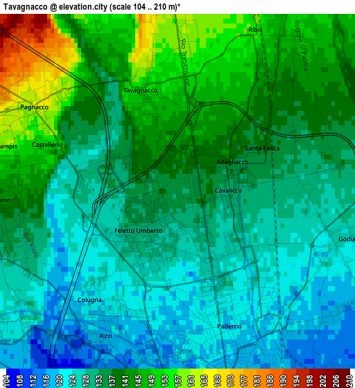
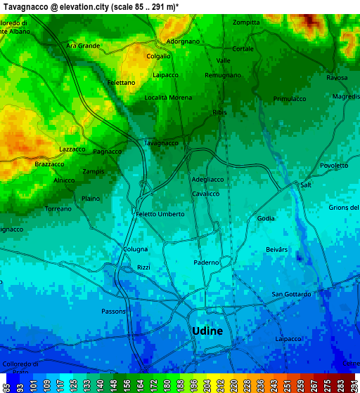
Below is the Elevation map of Tavagnacco, which displays elevation range with different colors. Scale of the first map is from 104 to 210 m (341 to 689 ft) with average elevation of 135.1 meters (=443 ft) [note 1]
These maps also provides idea of topography and contour of this city, they are displayed at different zoom levels. More info about maps, scale and edge coordinates you can find below images.
| \ | Map #1 | Map #2 | Topo.Map |
| Scale [m] | 104..210 m | 85..291 m | × |
| Scale [ft] | 341..689 ft | 279..955 ft | × |
| Average | 135.1 m = 443 ft | 140.3 m = 460 ft | × |
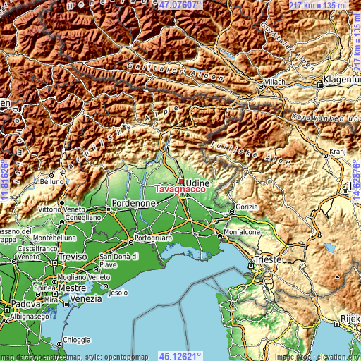
| Width | 6.78 km = 4.2 mi | 13.55 km = 8.4 mi | 216.8 km = 134.7 mi |
| Height | 6.78 km = 4.2 mi | 13.55 km = 8.4 mi | 216.8 km = 134.7 mi |
| ↑Max Latitude | 46.140218° | 46.170659° | 47.07607° |
| Latitude at center | 46.10976° | 46.10976° | 46.10976° |
| ↓Min Latitude | 46.079285° | 46.048794° | 45.12621° |
| ← Min Longitude | 13.178565° | 13.134619° | 11.81626° |
| Longitude center | 13.22251° | 13.22251° | 13.22251° |
| →Max Longitude | 13.266455° | 13.310401° | 14.62876° |
Nearby cities:
Cities around Tavagnacco sort by population:
• Udine elevation 116 m
4.6 km,  165°
165°
• Tricesimo 199 m
5.7 km,  354°
354°
• Pasian di Prato 99 m
7.5 km,  200°
200°
• Martignacco 131 m
6.6 km,  253°
253°
• Reana del Rojale 154 m
4.2 km,  26°
26°
• Pagnacco 150 m
3 km,  280°
280°
• Reana del Roiale 162 m
3.1 km,  0°
0°
• Cassacco 192 m
7.5 km,  341°
341°
• Passons 114 m
5.2 km,  209°
209°
• Colugna 122 m
2.6 km,  216°
216°
• Povoletto 129 m
5.4 km,  82°
82°
• Feletto Umberto 126 m
0.7 km,  183°
183°
Multilingual:
 En español:
Tavagnacco elevación 134 m.
 En France:
Tavagnacco élévation 134 m.
 Auf Deutsch:
Tavagnacco höhe über dem Meeresspiegel ist 134 m.

Sources and notes:
- [note 1] Map square and city borders are not equal. Map elevation data is calculated only from area inside that square.
- [src 1] Elevation data from geonames database provided with same terms of usage.
- [src 2] The elevation map of Tavagnacco is generated using elevation data from NASA's 3 arcsec (90m) resolution SRTM data.
- [src 3] Base (background) map © OpenStreetMap contributors tiles are generated by Geofabrik and OpenTopoMap.
Copyright & License:
This Tavagnacco Elevation Map is licensed under CC BY-SA. You may reuse any part from this page, if you give a proper credit by linking to this URL:
 More info on terms of use page.