Alfedena elevation
Alfedena (Abruzzo, Provincia dell' Aquila), Italy elevation is 892 meters and Alfedena elevation in feet is 2927 ft above sea level [src 1]. Alfedena is a seat of a third-order administrative division (feature code) with elevation that is 570 meters (1870 ft) bigger than average city elevation in Italy.
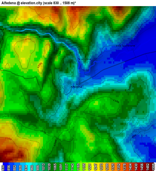
Below is the Elevation map of Alfedena, which displays elevation range with different colors. Scale of the first map is from 830 to 1508 m (2723 to 4948 ft) with average elevation of 1066.5 meters (=3499 ft) [note 1]
These maps also provides idea of topography and contour of this city, they are displayed at different zoom levels. More info about maps, scale and edge coordinates you can find below images.
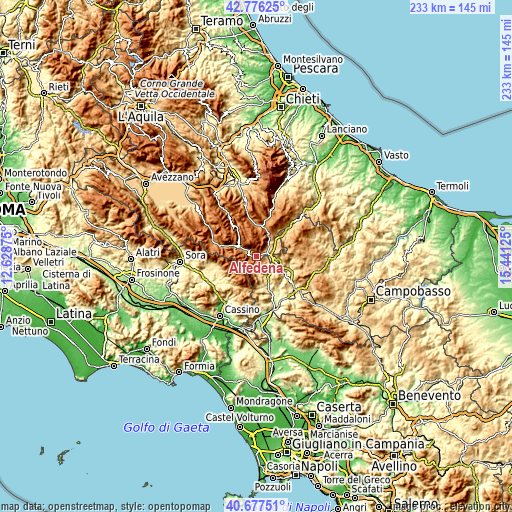
| \ | Map #1 | Topo.Map |
| Scale [m] | 830..1508 m | × |
| Scale [ft] | 2723..4948 ft | × |
| Average | 1066.5 m = 3499 ft | × |
| Width | 7.29 km = 4.5 mi | 233.4 km = 145 mi |
| Height | 7.29 km = 4.5 mi | 233.4 km = 145 mi |
| ↑Max Latitude | 41.768235° | 42.77625° |
| Latitude at center | 41.73545° | 41.73545° |
| ↓Min Latitude | 41.702648° | 40.67751° |
| ← Min Longitude | 13.991055° | 12.62875° |
| Longitude center | 14.035° | 14.035° |
| →Max Longitude | 14.078945° | 15.44125° |
Nearby cities:
Cities around Alfedena sort by population:
• Castel di Sangro elevation 800 m
8 km,  47°
47°
• Rionero Sannitico 1026 m
9 km,  106°
106°
• Barrea 1016 m
4.3 km,  301°
301°
• Villetta Barrea 987 m
9.2 km, 299°
• Montenero Val Cocchiara 904 m
3.5 km,  125°
125°
• Forlì del Sannio 625 m
12.8 km, 110°
• Acquaviva d'Isernia 719 m
11.8 km, 127°
• Castel San Vincenzo 711 m
9.2 km,  165°
165°
• Pizzone 676 m
6.9 km,  178°
178°
• Civitella Alfedena 1108 m
8.3 km,  293°
293°
• Cerro al Volturno 505 m
10.7 km,  147°
147°
• Scontrone 1036 m
1.3 km,  14°
14°
Multilingual:
 En español:
Alfedena elevación 892 m.
 En France:
Alfedena élévation 892 m.
 Auf Deutsch:
Alfedena höhe über dem Meeresspiegel ist 892 m.

Sources and notes:
- [note 1] Map square and city borders are not equal. Map elevation data is calculated only from area inside that square.
- [src 1] Elevation data from geonames database provided with same terms of usage.
- [src 2] The elevation map of Alfedena is generated using elevation data from NASA's 3 arcsec (90m) resolution SRTM data.
- [src 3] Base (background) map © OpenStreetMap contributors tiles are generated by Geofabrik and OpenTopoMap.
Copyright & License:
This Alfedena Elevation Map is licensed under CC BY-SA. You may reuse any part from this page, if you give a proper credit by linking to this URL:
 More info on terms of use page.