Castel di Sangro elevation
Castel di Sangro (Abruzzo, Provincia dell' Aquila), Italy elevation is 800 meters and Castel di Sangro elevation in feet is 2625 ft above sea level [src 1]. Castel di Sangro is a seat of a third-order administrative division (feature code) with elevation that is 478 meters (1568 ft) bigger than average city elevation in Italy.
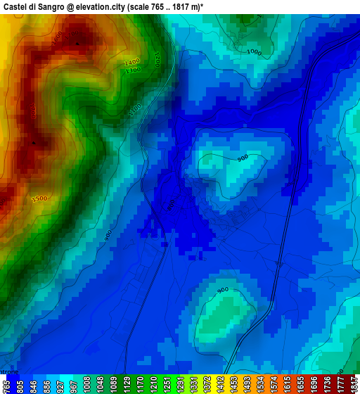
Below is the Elevation map of Castel di Sangro, which displays elevation range with different colors. Scale of the first map is from 765 to 1817 m (2510 to 5961 ft) with average elevation of 994.5 meters (=3263 ft) [note 1]
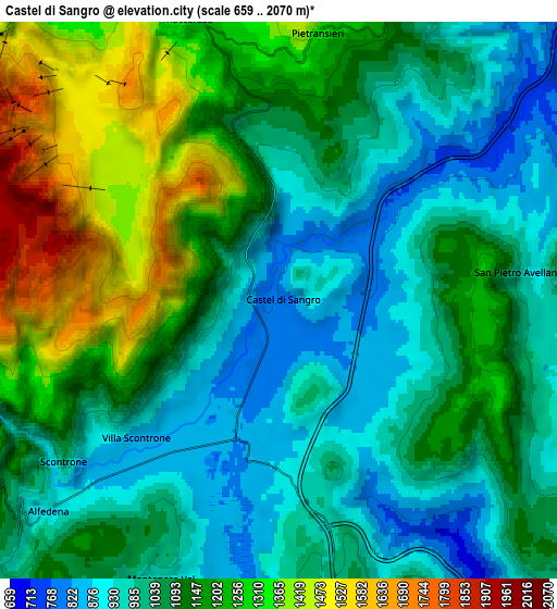
These maps also provides idea of topography and contour of this city, they are displayed at different zoom levels. More info about maps, scale and edge coordinates you can find below images.
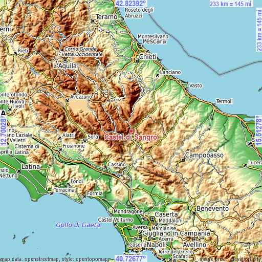
| \ | Map #1 | Map #2 | Topo.Map |
| Scale [m] | 765..1817 m | 659..2070 m | × |
| Scale [ft] | 2510..5961 ft | 2162..6791 ft | × |
| Average | 994.5 m = 3263 ft | 1103.7 m = 3621 ft | × |
| Width | 7.29 km = 4.5 mi | 14.57 km = 9.1 mi | 233.2 km = 144.9 mi |
| Height | 7.29 km = 4.5 mi | 14.57 km = 9.1 mi | 233.2 km = 144.9 mi |
| ↑Max Latitude | 41.81668° | 41.849423° | 42.82392° |
| Latitude at center | 41.78392° | 41.78392° | 41.78392° |
| ↓Min Latitude | 41.751143° | 41.71835° | 40.72677° |
| ← Min Longitude | 14.062585° | 14.018639° | 12.70028° |
| Longitude center | 14.10653° | 14.10653° | 14.10653° |
| →Max Longitude | 14.150475° | 14.194421° | 15.51278° |
Nearby cities:
Cities around Castel di Sangro sort by population:
• Roccaraso elevation 1248 m
7.6 km,  342°
342°
• Pescocostanzo 1367 m
12 km, 343°
• Rionero Sannitico 1026 m
8.4 km,  161°
161°
• Alfedena 892 m
8 km,  227°
227°
• Barrea 1016 m
10.1 km,  251°
251°
• Rivisondoli 1303 m
10.1 km, 341°
• Ateleta 763 m
10.9 km,  44°
44°
• Montenero Val Cocchiara 904 m
8.1 km,  202°
202°
• Forlì del Sannio 625 m
11.5 km,  148°
148°
• Vastogirardi 1159 m
12.6 km,  94°
94°
• San Pietro Avellana 968 m
6.4 km, 85°
• Scontrone 1036 m
7 km, 233°
Multilingual:
 En español:
Castel di Sangro elevación 800 m.
 En France:
Castel di Sangro élévation 800 m.
 Auf Deutsch:
Castel di Sangro höhe über dem Meeresspiegel ist 800 m.

Sources and notes:
- [note 1] Map square and city borders are not equal. Map elevation data is calculated only from area inside that square.
- [src 1] Elevation data from geonames database provided with same terms of usage.
- [src 2] The elevation map of Castel di Sangro is generated using elevation data from NASA's 3 arcsec (90m) resolution SRTM data.
- [src 3] Base (background) map © OpenStreetMap contributors tiles are generated by Geofabrik and OpenTopoMap.
Copyright & License:
This Castel di Sangro Elevation Map is licensed under CC BY-SA. You may reuse any part from this page, if you give a proper credit by linking to this URL:
 More info on terms of use page.