Ateleta elevation
Ateleta (Abruzzo, Provincia dell' Aquila), Italy elevation is 763 meters and Ateleta elevation in feet is 2503 ft above sea level [src 1]. Ateleta is a seat of a third-order administrative division (feature code) with elevation that is 441 meters (1447 ft) bigger than average city elevation in Italy.
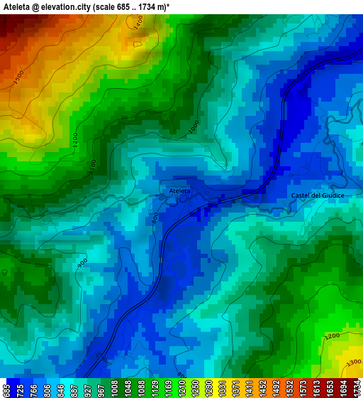
Below is the Elevation map of Ateleta, which displays elevation range with different colors. Scale of the first map is from 685 to 1734 m (2247 to 5689 ft) with average elevation of 966.2 meters (=3170 ft) [note 1]
These maps also provides idea of topography and contour of this city, they are displayed at different zoom levels. More info about maps, scale and edge coordinates you can find below images.
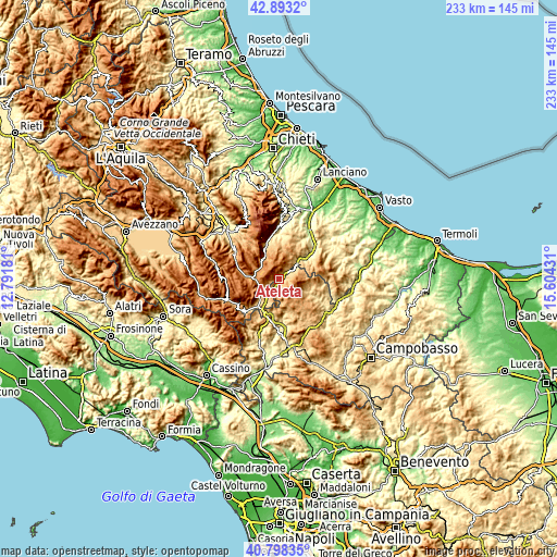
| \ | Map #1 | Topo.Map |
| Scale [m] | 685..1734 m | × |
| Scale [ft] | 2247..5689 ft | × |
| Average | 966.2 m = 3170 ft | × |
| Width | 7.28 km = 4.5 mi | 232.9 km = 144.7 mi |
| Height | 7.28 km = 4.5 mi | 232.9 km = 144.7 mi |
| ↑Max Latitude | 41.887074° | 42.8932° |
| Latitude at center | 41.85435° | 41.85435° |
| ↓Min Latitude | 41.821609° | 40.79835° |
| ← Min Longitude | 14.154115° | 12.79181° |
| Longitude center | 14.19806° | 14.19806° |
| →Max Longitude | 14.242005° | 15.60431° |
Nearby cities:
Cities around Ateleta sort by population:
• Castel di Sangro elevation 800 m
10.9 km,  224°
224°
• Roccaraso 1248 m
9.9 km,  266°
266°
• Capracotta 1384 m
6.1 km,  112°
112°
• Quadri 627 m
10.7 km,  43°
43°
• Rivisondoli 1303 m
11 km,  279°
279°
• Vastogirardi 1159 m
10.2 km,  150°
150°
• San Pietro Avellana 968 m
7.4 km,  189°
189°
• Pizzoferrato 1190 m
8.2 km,  22°
22°
• Sant'Angelo del Pesco 780 m
5.5 km,  56°
56°
• Castel del Giudice 811 m
2.8 km,  88°
88°
• Pescopennataro 1209 m
8.4 km,  71°
71°
• Gamberale 1318 m
5.7 km,  8°
8°
Multilingual:
 En español:
Ateleta elevación 763 m.
 En France:
Ateleta élévation 763 m.


Sources and notes:
- [note 1] Map square and city borders are not equal. Map elevation data is calculated only from area inside that square.
- [src 1] Elevation data from geonames database provided with same terms of usage.
- [src 2] The elevation map of Ateleta is generated using elevation data from NASA's 3 arcsec (90m) resolution SRTM data.
- [src 3] Base (background) map © OpenStreetMap contributors tiles are generated by Geofabrik and OpenTopoMap.
Copyright & License:
This Ateleta Elevation Map is licensed under CC BY-SA. You may reuse any part from this page, if you give a proper credit by linking to this URL:
 More info on terms of use page.