Quadri elevation
Quadri (Abruzzo, Provincia di Chieti), Italy elevation is 627 meters and Quadri elevation in feet is 2057 ft above sea level [src 1]. Quadri is a seat of a third-order administrative division (feature code) with elevation that is 305 meters (1001 ft) bigger than average city elevation in Italy.
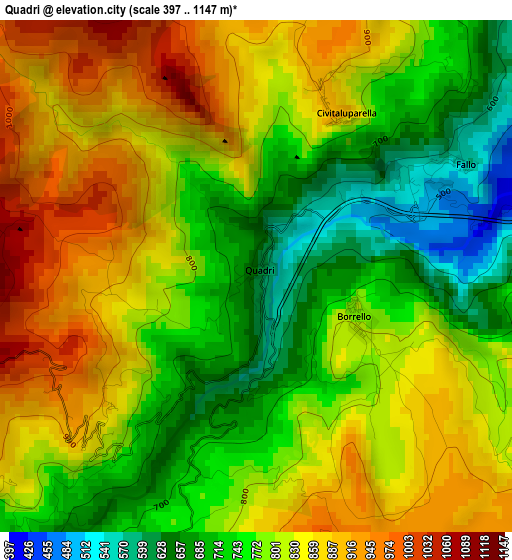
Below is the Elevation map of Quadri, which displays elevation range with different colors. Scale of the first map is from 397 to 1147 m (1302 to 3763 ft) with average elevation of 798.3 meters (=2619 ft) [note 1]
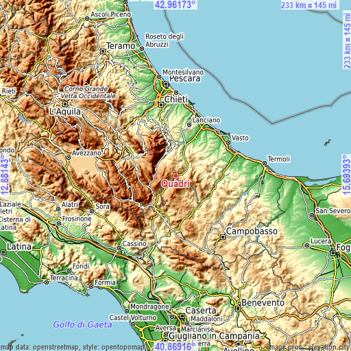
These maps also provides idea of topography and contour of this city, they are displayed at different zoom levels. More info about maps, scale and edge coordinates you can find below images.
| \ | Map #1 | Topo.Map |
| Scale [m] | 397..1147 m | × |
| Scale [ft] | 1302..3763 ft | × |
| Average | 798.3 m = 2619 ft | × |
| Width | 7.27 km = 4.5 mi | 232.7 km = 144.6 mi |
| Height | 7.27 km = 4.5 mi | 232.7 km = 144.6 mi |
| ↑Max Latitude | 41.956708° | 42.96173° |
| Latitude at center | 41.92402° | 41.92402° |
| ↓Min Latitude | 41.891315° | 40.86916° |
| ← Min Longitude | 14.243735° | 12.88143° |
| Longitude center | 14.28768° | 14.28768° |
| →Max Longitude | 14.331625° | 15.69393° |
Nearby cities:
Cities around Quadri sort by population:
• Villa Santa Maria elevation 317 m
6.1 km,  60°
60°
• Montenerodomo 1152 m
6.6 km,  333°
333°
• Pizzoferrato 1190 m
4.3 km,  267°
267°
• Sant'Angelo del Pesco 780 m
5.5 km,  211°
211°
• Borrello 802 m
1.6 km,  117°
117°
• Civitaluparella 907 m
2.6 km,  25°
25°
• Pescopennataro 1209 m
5.2 km,  174°
174°
• Rosello 925 m
5.7 km, 116°
• Fallo 571 m
3.4 km, 61°
• Roio del Sangro 851 m
7.3 km,  101°
101°
• Gamberale 1318 m
6.9 km,  252°
252°
• Montelapiano 709 m
6.2 km,  46°
46°
Multilingual:
 En español:
Quadri elevación 627 m.
 En France:
Quadri élévation 627 m.


Sources and notes:
- [note 1] Map square and city borders are not equal. Map elevation data is calculated only from area inside that square.
- [src 1] Elevation data from geonames database provided with same terms of usage.
- [src 2] The elevation map of Quadri is generated using elevation data from NASA's 3 arcsec (90m) resolution SRTM data.
- [src 3] Base (background) map © OpenStreetMap contributors tiles are generated by Geofabrik and OpenTopoMap.
Copyright & License:
This Quadri Elevation Map is licensed under CC BY-SA. You may reuse any part from this page, if you give a proper credit by linking to this URL:
 More info on terms of use page.