Anzola d'Ossola elevation
Anzola d'Ossola (Piedmont, Provincia Verbano-Cusio-Ossola), Italy elevation is 216 meters and Anzola d'Ossola elevation in feet is 709 ft above sea level [src 1]. Anzola d'Ossola is a seat of a third-order administrative division (feature code) with elevation that is 106 meters (348 ft) smaller than average city elevation in Italy.
Below is the Elevation map of Anzola d'Ossola, which displays elevation range with different colors. Scale of the first map is from 201 to 1899 m (659 to 6230 ft) with average elevation of 711.2 meters (=2333 ft) [note 1]
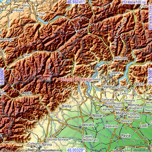
These maps also provides idea of topography and contour of this city, they are displayed at different zoom levels. More info about maps, scale and edge coordinates you can find below images.
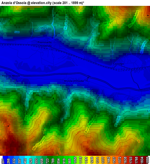
| \ | Map #1 | Topo.Map |
| Scale [m] | 201..1899 m | × |
| Scale [ft] | 659..6230 ft | × |
| Average | 711.2 m = 2333 ft | × |
| Width | 6.79 km = 4.2 mi | 217.3 km = 135 mi |
| Height | 6.79 km = 4.2 mi | 217.3 km = 135 mi |
| ↑Max Latitude | 46.019495° | 46.95741° |
| Latitude at center | 45.98897° | 45.98897° |
| ↓Min Latitude | 45.958429° | 45.00329° |
| ← Min Longitude | 8.301365° | 6.93906° |
| Longitude center | 8.34531° | 8.34531° |
| →Max Longitude | 8.389255° | 9.75156° |
Nearby cities:
Cities around Anzola d'Ossola sort by population:
• Gravellona Toce elevation 214 m
9.5 km,  135°
135°
• Ornavasso 215 m
5.9 km,  113°
113°
• Pieve Vergonte 235 m
7.1 km,  292°
292°
• Mergozzo 215 m
8.9 km, 109°
• Vogogna 222 m
4.8 km,  299°
299°
• Valstrona 514 m
9 km,  181°
181°
• Premosello-Chiovenda 227 m
2 km,  323°
323°
• Piedimulera 248 m
7.7 km, 300°
• Casale Corte Cerro 382 m
9.8 km,  146°
146°
• Pallanzeno 231 m
8.9 km,  311°
311°
• Loreglia 725 m
9.3 km,  167°
167°
• Massiola 796 m
8.7 km,  192°
192°
Multilingual:
 En español:
Anzola d'Ossola elevación 216 m.
 En France:
Anzola d'Ossola élévation 216 m.
 Auf Deutsch:
Anzola d'Ossola höhe über dem Meeresspiegel ist 216 m.

Sources and notes:
- [note 1] Map square and city borders are not equal. Map elevation data is calculated only from area inside that square.
- [src 1] Elevation data from geonames database provided with same terms of usage.
- [src 2] The elevation map of Anzola d'Ossola is generated using elevation data from NASA's 3 arcsec (90m) resolution SRTM data.
- [src 3] Base (background) map © OpenStreetMap contributors tiles are generated by Geofabrik and OpenTopoMap.
Copyright & License:
This Anzola d'Ossola Elevation Map is licensed under CC BY-SA. You may reuse any part from this page, if you give a proper credit by linking to this URL:
 More info on terms of use page.