Vogogna elevation
Vogogna (Piedmont, Provincia Verbano-Cusio-Ossola), Italy elevation is 222 meters and Vogogna elevation in feet is 728 ft above sea level [src 1]. Vogogna is a seat of a third-order administrative division (feature code) with elevation that is 100 meters (328 ft) smaller than average city elevation in Italy.
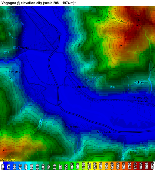
Below is the Elevation map of Vogogna, which displays elevation range with different colors. Scale of the first map is from 208 to 1974 m (682 to 6476 ft) with average elevation of 606.5 meters (=1990 ft) [note 1]
These maps also provides idea of topography and contour of this city, they are displayed at different zoom levels. More info about maps, scale and edge coordinates you can find below images.
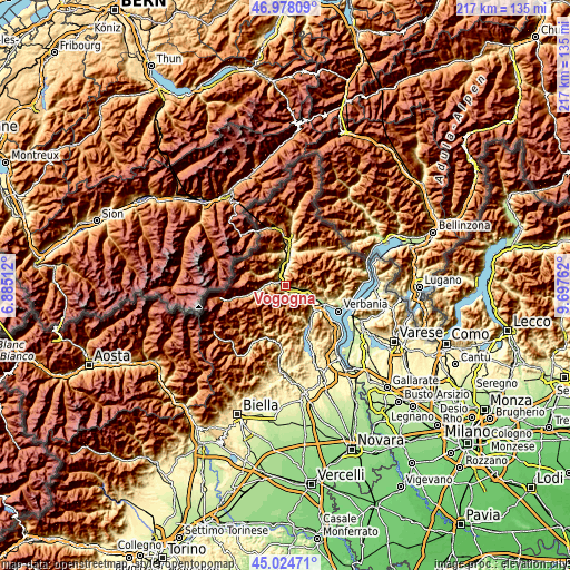
| \ | Map #1 | Topo.Map |
| Scale [m] | 208..1974 m | × |
| Scale [ft] | 682..6476 ft | × |
| Average | 606.5 m = 1990 ft | × |
| Width | 6.79 km = 4.2 mi | 217.2 km = 135 mi |
| Height | 6.79 km = 4.2 mi | 217.2 km = 135 mi |
| ↑Max Latitude | 46.040533° | 46.97809° |
| Latitude at center | 46.01002° | 46.01002° |
| ↓Min Latitude | 45.97949° | 45.02471° |
| ← Min Longitude | 8.247425° | 6.88512° |
| Longitude center | 8.29137° | 8.29137° |
| →Max Longitude | 8.335315° | 9.69762° |
Nearby cities:
Cities around Vogogna sort by population:
• Villadossola elevation 252 m
7 km,  344°
344°
• Ornavasso 215 m
10.7 km,  115°
115°
• Pieve Vergonte 235 m
2.4 km,  277°
277°
• Premosello-Chiovenda 227 m
3 km,  103°
103°
• Piedimulera 248 m
3 km,  302°
302°
• Pallanzeno 231 m
4.3 km,  325°
325°
• Calasca-Castiglione 524 m
6.1 km, 281°
• Beura 250 m
7.8 km,  3°
3°
• Montescheno 554 m
7.8 km,  323°
323°
• Anzola d'Ossola 216 m
4.8 km, 119°
• Seppiana 539 m
7.9 km,  312°
312°
• Viganella 570 m
8.8 km, 301°
Multilingual:
 En español:
Vogogna elevación 222 m.
 En France:
Vogogna élévation 222 m.


Sources and notes:
- [note 1] Map square and city borders are not equal. Map elevation data is calculated only from area inside that square.
- [src 1] Elevation data from geonames database provided with same terms of usage.
- [src 2] The elevation map of Vogogna is generated using elevation data from NASA's 3 arcsec (90m) resolution SRTM data.
- [src 3] Base (background) map © OpenStreetMap contributors tiles are generated by Geofabrik and OpenTopoMap.
Copyright & License:
This Vogogna Elevation Map is licensed under CC BY-SA. You may reuse any part from this page, if you give a proper credit by linking to this URL:
 More info on terms of use page.