Valstrona elevation
Valstrona (Piedmont, Provincia Verbano-Cusio-Ossola), Italy elevation is 514 meters and Valstrona elevation in feet is 1686 ft above sea level [src 1]. Valstrona is a seat of a third-order administrative division (feature code) with elevation that is 192 meters (630 ft) bigger than average city elevation in Italy.
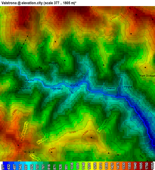
Below is the Elevation map of Valstrona, which displays elevation range with different colors. Scale of the first map is from 377 to 1805 m (1237 to 5922 ft) with average elevation of 1059.2 meters (=3475 ft) [note 1]
These maps also provides idea of topography and contour of this city, they are displayed at different zoom levels. More info about maps, scale and edge coordinates you can find below images.
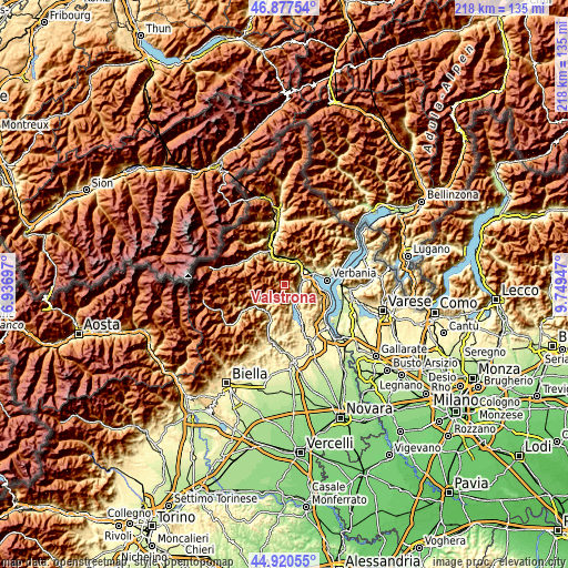
| \ | Map #1 | Topo.Map |
| Scale [m] | 377..1805 m | × |
| Scale [ft] | 1237..5922 ft | × |
| Average | 1059.2 m = 3475 ft | × |
| Width | 6.8 km = 4.2 mi | 217.6 km = 135.2 mi |
| Height | 6.8 km = 4.2 mi | 217.6 km = 135.2 mi |
| ↑Max Latitude | 45.938239° | 46.87754° |
| Latitude at center | 45.90767° | 45.90767° |
| ↓Min Latitude | 45.877084° | 44.92055° |
| ← Min Longitude | 8.299275° | 6.93697° |
| Longitude center | 8.34322° | 8.34322° |
| →Max Longitude | 8.387165° | 9.74947° |
Nearby cities:
Cities around Valstrona sort by population:
• Omegna elevation 307 m
5.8 km,  122°
122°
• Gravellona Toce 214 m
7.3 km,  71°
71°
• Ornavasso 215 m
8.7 km,  39°
39°
• Gabbio-Cereda-Ramate 259 m
6 km,  87°
87°
• Casale Corte Cerro 382 m
5.5 km,  81°
81°
• Cesara 487 m
8.4 km,  166°
166°
• Nonio 468 m
7.4 km,  158°
158°
• Quarna Sotto 794 m
4.6 km, 160°
• Quarna Sopra 850 m
4.5 km,  148°
148°
• Germagno 592 m
3.8 km, 115°
• Loreglia 725 m
2.2 km, 92°
• Massiola 796 m
1.9 km,  286°
286°
Multilingual:
 En español:
Valstrona elevación 514 m.
 En France:
Valstrona élévation 514 m.
 Auf Deutsch:
Valstrona höhe über dem Meeresspiegel ist 514 m.

Sources and notes:
- [note 1] Map square and city borders are not equal. Map elevation data is calculated only from area inside that square.
- [src 1] Elevation data from geonames database provided with same terms of usage.
- [src 2] The elevation map of Valstrona is generated using elevation data from NASA's 3 arcsec (90m) resolution SRTM data.
- [src 3] Base (background) map © OpenStreetMap contributors tiles are generated by Geofabrik and OpenTopoMap.
Copyright & License:
This Valstrona Elevation Map is licensed under CC BY-SA. You may reuse any part from this page, if you give a proper credit by linking to this URL:
 More info on terms of use page.