Cesara elevation
Cesara (Piedmont, Provincia Verbano-Cusio-Ossola), Italy elevation is 487 meters and Cesara elevation in feet is 1598 ft above sea level [src 1]. Cesara is a seat of a third-order administrative division (feature code) with elevation that is 165 meters (541 ft) bigger than average city elevation in Italy.
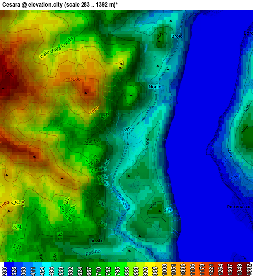
Below is the Elevation map of Cesara, which displays elevation range with different colors. Scale of the first map is from 283 to 1392 m (928 to 4567 ft) with average elevation of 630.1 meters (=2067 ft) [note 1]
These maps also provides idea of topography and contour of this city, they are displayed at different zoom levels. More info about maps, scale and edge coordinates you can find below images.
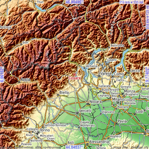
| \ | Map #1 | Topo.Map |
| Scale [m] | 283..1392 m | × |
| Scale [ft] | 928..4567 ft | × |
| Average | 630.1 m = 2067 ft | × |
| Width | 6.81 km = 4.2 mi | 217.9 km = 135.4 mi |
| Height | 6.81 km = 4.2 mi | 217.9 km = 135.4 mi |
| ↑Max Latitude | 45.8644° | 46.80496° |
| Latitude at center | 45.83379° | 45.83379° |
| ↓Min Latitude | 45.803163° | 44.84537° |
| ← Min Longitude | 8.323825° | 6.96152° |
| Longitude center | 8.36777° | 8.36777° |
| →Max Longitude | 8.411715° | 9.77402° |
Nearby cities:
Cities around Cesara sort by population:
• Omegna elevation 307 m
6 km,  30°
30°
• Armeno 522 m
6.2 km,  103°
103°
• Pettenasco 302 m
3.6 km,  122°
122°
• Orta San Giulio 329 m
5.4 km,  138°
138°
• Pella 298 m
4.3 km,  162°
162°
• Madonna del Sasso 685 m
4.6 km,  178°
178°
• Nonio 468 m
1.5 km, 29°
• Quarna Sotto 794 m
3.9 km,  354°
354°
• Miasino 474 m
6 km,  126°
126°
• Quarna Sopra 850 m
4.4 km,  5°
5°
• Arola 618 m
2.9 km,  195°
195°
• Civiasco 717 m
6.4 km,  243°
243°
Multilingual:
 En español:
Cesara elevación 487 m.
 En France:
Cesara élévation 487 m.


Sources and notes:
- [note 1] Map square and city borders are not equal. Map elevation data is calculated only from area inside that square.
- [src 1] Elevation data from geonames database provided with same terms of usage.
- [src 2] The elevation map of Cesara is generated using elevation data from NASA's 3 arcsec (90m) resolution SRTM data.
- [src 3] Base (background) map © OpenStreetMap contributors tiles are generated by Geofabrik and OpenTopoMap.
Copyright & License:
This Cesara Elevation Map is licensed under CC BY-SA. You may reuse any part from this page, if you give a proper credit by linking to this URL:
 More info on terms of use page.