Pettenasco elevation
Pettenasco (Piedmont, Provincia di Novara), Italy elevation is 302 meters and Pettenasco elevation in feet is 991 ft above sea level [src 1]. Pettenasco is a seat of a third-order administrative division (feature code) with elevation that is 20 meters (66 ft) smaller than average city elevation in Italy.
Below is the Elevation map of Pettenasco, which displays elevation range with different colors. Scale of the first map is from 283 to 1028 m (928 to 3373 ft) with average elevation of 453.6 meters (=1488 ft) [note 1]
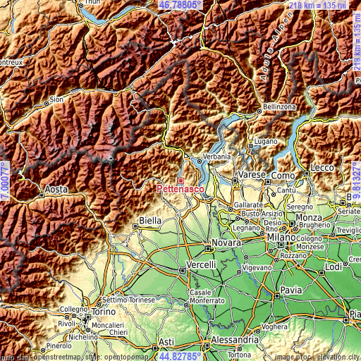
These maps also provides idea of topography and contour of this city, they are displayed at different zoom levels. More info about maps, scale and edge coordinates you can find below images.
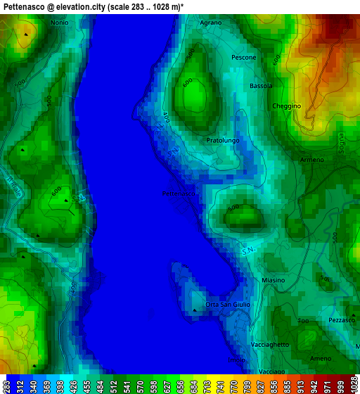
| \ | Map #1 | Topo.Map |
| Scale [m] | 283..1028 m | × |
| Scale [ft] | 928..3373 ft | × |
| Average | 453.6 m = 1488 ft | × |
| Width | 6.81 km = 4.2 mi | 218 km = 135.5 mi |
| Height | 6.81 km = 4.2 mi | 217.9 km = 135.4 mi |
| ↑Max Latitude | 45.84719° | 46.78805° |
| Latitude at center | 45.81657° | 45.81657° |
| ↓Min Latitude | 45.785934° | 44.82785° |
| ← Min Longitude | 8.363075° | 7.00077° |
| Longitude center | 8.40702° | 8.40702° |
| →Max Longitude | 8.450965° | 9.81327° |
Nearby cities:
Cities around Pettenasco sort by population:
• San Maurizio D'Opaglio elevation 370 m
4.9 km,  190°
190°
• Armeno 522 m
3 km,  81°
81°
• Pogno 461 m
6.7 km, 194°
• Bolzano Novarese 397 m
6.6 km,  155°
155°
• Orta San Giulio 329 m
2.2 km,  165°
165°
• Pella 298 m
2.8 km,  219°
219°
• Ameno 532 m
4 km,  140°
140°
• Madonna del Sasso 685 m
4 km,  226°
226°
• Cesara 487 m
3.6 km,  302°
302°
• Nonio 468 m
4 km,  324°
324°
• Miasino 474 m
2.4 km,  132°
132°
• Arola 618 m
3.9 km,  256°
256°
Multilingual:
 En español:
Pettenasco elevación 302 m.
 En France:
Pettenasco élévation 302 m.
 Auf Deutsch:
Pettenasco höhe über dem Meeresspiegel ist 302 m.

Sources and notes:
- [note 1] Map square and city borders are not equal. Map elevation data is calculated only from area inside that square.
- [src 1] Elevation data from geonames database provided with same terms of usage.
- [src 2] The elevation map of Pettenasco is generated using elevation data from NASA's 3 arcsec (90m) resolution SRTM data.
- [src 3] Base (background) map © OpenStreetMap contributors tiles are generated by Geofabrik and OpenTopoMap.
Copyright & License:
This Pettenasco Elevation Map is licensed under CC BY-SA. You may reuse any part from this page, if you give a proper credit by linking to this URL:
 More info on terms of use page.